Category:Christina's Hoeve (Zoeterwoude-Dorp)
Jump to navigation
Jump to search
| Object location | | View all coordinates using: OpenStreetMap |
|---|
,_Christina%27s_hoeve.JPG) | |||||
| Upload media | |||||
| Instance of | |||||
|---|---|---|---|---|---|
| Location | Zoeterwoude, South Holland, Netherlands | ||||
| Street address |
| ||||
| Heritage designation |
| ||||
 | |||||
|
This is a category about rijksmonument number 41060
|
| Address |
|
Media in category "Christina's Hoeve (Zoeterwoude-Dorp)"
The following 107 files are in this category, out of 107 total.
-
 Achtergevel - Zoeterwoude - 20224946 - RCE.jpg 2,880 × 2,292; 1.55 MB
-
 Achtergevel schuur, tijdens de verbouwing - Zoeterwoude-dorp - 20402755 - RCE.jpg 3,099 × 3,099; 1.8 MB
-
 Christina's Hoeve - Zoeterwoude-dorp - 20410916 - RCE.jpg 1,200 × 798; 126 KB
-

-
 Gedeelte achtergevel - Zoeterwoude - 20224945 - RCE.jpg 1,200 × 955; 377 KB
-
 Gedeelte rechter zijgevel - Zoeterwoude-dorp - 20349643 - RCE.jpg 1,200 × 1,200; 410 KB
-
 Interieur bedstee - Zoeterwoude - 20224947 - RCE.jpg 974 × 1,200; 185 KB
-

-
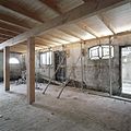
 Interieur overzicht bijgebouw - Zoeterwoude-dorp - 20411693 - RCE.jpg 1,200 × 798; 123 KB
-
 Interieur overzicht bijgebouw - Zoeterwoude-dorp - 20411694 - RCE.jpg 1,200 × 798; 77 KB
-
 Interieur overzicht bijkeuken - Zoeterwoude-dorp - 20411699 - RCE.jpg 1,200 × 798; 128 KB
-
 Interieur overzicht keuken in bijgebouw - Zoeterwoude-dorp - 20411695 - RCE.jpg 1,200 × 798; 162 KB
-
 Interieur overzicht keuken in bijgebouw - Zoeterwoude-dorp - 20411696 - RCE.jpg 1,200 × 798; 132 KB
-
 Interieur overzicht keuken in bijgebouw - Zoeterwoude-dorp - 20411697 - RCE.jpg 1,200 × 798; 205 KB
-
 Interieur overzicht keuken in bijgebouw - Zoeterwoude-dorp - 20411698 - RCE.jpg 1,200 × 798; 158 KB
-

-

-

-

-

-

-

-

-

-

-

-

-

-

-

-

-

-

-

-

-

-

-

-

-
 Interieur voorhuis, kamer met schouw - Zoeterwoude-dorp - 20349625 - RCE.jpg 1,200 × 1,200; 256 KB
-

-
 Interieur voorhuis, korbeel - Zoeterwoude-dorp - 20349626 - RCE.jpg 1,200 × 1,200; 179 KB
-
 Interieur voorhuis, overzicht bedstede - Zoeterwoude-dorp - 20349624 - RCE.jpg 1,200 × 1,200; 212 KB
-

-
 Interieur voorhuis, overzicht bedstedewand, open - Zoeterwoude-dorp - 20349628 - RCE.jpg 1,200 × 1,200; 179 KB
-
 Interieur voorhuis, overzicht kelder - Zoeterwoude-dorp - 20349633 - RCE.jpg 1,200 × 1,196; 204 KB
-
 Interieur voorhuis, overzicht korbelen - Zoeterwoude-dorp - 20349631 - RCE.jpg 1,200 × 1,200; 210 KB
-
 Interieur voorhuis, overzicht trappen - Zoeterwoude-dorp - 20349630 - RCE.jpg 1,200 × 1,200; 175 KB
-
 Interieur voorhuis, overzicht zolder - Zoeterwoude-dorp - 20349632 - RCE.jpg 1,200 × 1,200; 234 KB
-
 Interieur voorhuis, restant spiltrap - Zoeterwoude-dorp - 20349629 - RCE.jpg 1,200 × 1,200; 146 KB
-

-

-

-

-

-

-

-

-

-

-

-
-
 Interieur, overzicht veestalling - Zoeterwoude-dorp - 20349636 - RCE.jpg 1,200 × 1,200; 294 KB
-
 Interieur, overzicht veestalling - Zoeterwoude-dorp - 20349637 - RCE.jpg 1,200 × 1,200; 249 KB
-

-
 Linker zijgevel - Zoeterwoude - 20224943 - RCE.jpg 1,200 × 963; 414 KB
-
 Linker zijgevel met keldervenster - Zoeterwoude-dorp - 20349635 - RCE.jpg 1,200 × 1,200; 344 KB
-
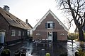
 Netherlands, Zoeterwoude, Westeinde (1), Christina's hoeve.JPG 1,930 × 1,282; 1.13 MB
-
 Overizcht met zijgevel - Zoeterwoude-dorp - 20426171 - RCE.jpg 1,200 × 798; 266 KB
-
 Overizcht van de straatzijde en zijgevel - Zoeterwoude-dorp - 20426172 - RCE.jpg 1,200 × 798; 171 KB
-
 Overzicht - Zoeterwoude - 20224941 - RCE.jpg 1,200 × 959; 409 KB
-
 Overzicht - Zoeterwoude-dorp - 20349638 - RCE.jpg 1,200 × 1,200; 395 KB
-
 Overzicht achtergevels - Zoeterwoude-dorp - 20349644 - RCE.jpg 1,200 × 1,200; 375 KB
-
 Overzicht rechter zijgevel - Zoeterwoude-dorp - 20349640 - RCE.jpg 1,200 × 1,200; 368 KB
-
 Overzicht rechter zijgevel - Zoeterwoude-dorp - 20349641 - RCE.jpg 1,200 × 1,200; 386 KB
-
 Overzicht van de achtergevel - Zoeterwoude-dorp - 20426155 - RCE.jpg 1,200 × 798; 168 KB
-
 Overzicht van de achtergevel - Zoeterwoude-dorp - 20426156 - RCE.jpg 1,200 × 798; 215 KB
-
 Overzicht van de achtergevel - Zoeterwoude-dorp - 20426157 - RCE.jpg 4,256 × 2,832; 2.91 MB
-
 Overzicht van de achtergevel - Zoeterwoude-dorp - 20426158 - RCE.jpg 1,200 × 798; 240 KB
-
 Overzicht van de achtergevel - Zoeterwoude-dorp - 20426159 - RCE.jpg 1,200 × 798; 192 KB
-
 Overzicht van de voorgevel - Zoeterwoude-dorp - 20426154 - RCE.jpg 798 × 1,200; 266 KB
-
 Overzicht van de voorgevel - Zoeterwoude-dorp - 20426165 - RCE.jpg 1,200 × 800; 228 KB
-
 Overzicht van de voorgevel - Zoeterwoude-dorp - 20426166 - RCE.jpg 1,200 × 798; 225 KB
-
 Overzicht van de voorgevel en zijgevel - Zoeterwoude-dorp - 20426167 - RCE.jpg 1,200 × 798; 225 KB
-
 Overzicht van de zijgevel - Zoeterwoude-dorp - 20426162 - RCE.jpg 1,200 × 798; 226 KB
-
 Overzicht van de zijgevel - Zoeterwoude-dorp - 20426163 - RCE.jpg 1,200 × 798; 247 KB
-
 Overzicht van de zijgevel - Zoeterwoude-dorp - 20426164 - RCE.jpg 1,200 × 798; 225 KB
-

-

-

-

-

-
 Overzicht voorgevel - Zoeterwoude-dorp - 20349639 - RCE.jpg 1,200 × 1,200; 395 KB
-
 Overzicht voorgevel van boerderij vanaf de weg - Zoeterwoude-dorp - 20402750 - RCE.jpg 1,200 × 1,200; 437 KB
-
 Overzicht voorgevel van boerderij vanaf de weg - Zoeterwoude-dorp - 20402751 - RCE.jpg 1,200 × 1,200; 459 KB
-
 Rechter zijgevel - Zoeterwoude - 20224944 - RCE.jpg 1,200 × 966; 375 KB
-
 Rechter zijgevel - Zoeterwoude-dorp - 20349642 - RCE.jpg 1,200 × 1,200; 360 KB
-
 Uitzicht vanaf de voorgevel - Zoeterwoude-dorp - 20426169 - RCE.jpg 1,200 × 798; 88 KB
-
 Voorgevels - Zoeterwoude - 20224942 - RCE.jpg 1,200 × 951; 372 KB
-
 Westeindseweg 6, Christina's hoeve - Zoeterwoude - 20224809 - RCE.jpg 1,200 × 803; 286 KB
-
 Westeindseweg 6.JPG 3,072 × 2,048; 2.99 MB
-
 Zicht op de achterzijde stal met wolfdak - Zoeterwoude-dorp - 20411711 - RCE.jpg 4,064 × 2,704; 1.92 MB
-
 Zicht op de achterzijde stal met wolfdak - Zoeterwoude-dorp - 20411712 - RCE.jpg 4,064 × 2,704; 2.18 MB
-

-
 Zicht op de zijgevel van de stal - Zoeterwoude-dorp - 20411713 - RCE.jpg 4,064 × 2,704; 2.04 MB
-
 Zicht op de zijgevel van het woonhuis - Zoeterwoude-dorp - 20411717 - RCE.jpg 798 × 1,200; 236 KB
-


