Category:Christ the King church in Kára
Jump to navigation
Jump to search
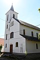
Magyar: Római katolikus Krisztus király templom, Kára, Somogy megye.
| Object location | | View all coordinates using: OpenStreetMap |
|---|
Subcategories
This category has only the following subcategory.
Media in category "Christ the King church in Kára"
The following 3 files are in this category, out of 3 total.
-
 Kára, római katolikus templom 2021 01.jpg 1,600 × 2,400; 788 KB
-
 Kára, római katolikus templom 2021 02.jpg 1,600 × 2,400; 540 KB
-
 Kára, római katolikus templom 2021 03.jpg 1,600 × 2,400; 814 KB


