Category:Chorherren- und Pfrundhäuser Südgruppe, Beromünster
Jump to navigation
Jump to search
| Object location | | View all coordinates using: OpenStreetMap |
|---|
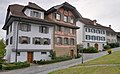
residential buildings in Beromünster in the canton of Lucerne, Switzerland  | |||||
| Upload media | |||||
| Instance of | |||||
|---|---|---|---|---|---|
| Part of | |||||
| Location | Beromünster, Sursee Constituency, Lucerne, Switzerland | ||||
| Street address |
| ||||
| Heritage designation | |||||
 | |||||
Media in category "Chorherren- und Pfrundhäuser Südgruppe, Beromünster"
The following 6 files are in this category, out of 6 total.
-
 Beromünster, Chorherren- und Pfrundhäuser Südgruppe IMG 4697.jpg 3,088 × 2,056; 2.99 MB
-
 Beromünster, Chorherren- und Pfrundhäuser Südgruppe IMG 4699.jpg 2,056 × 3,088; 2.38 MB
-
 Beromünster, Chorherren- und Pfrundhäuser Südgruppe IMG 4734.jpg 3,088 × 2,056; 3.1 MB
-
 Chorherren- und Pfrundhaeuser Suedgruppe Beromuenster 2011.jpg 4,192 × 2,588; 2.63 MB
-
 Stift Beromünster DSC04674.jpg 3,691 × 2,076; 2.11 MB
-
 Stift Beromünster DSC04675.jpg 4,000 × 2,672; 3.13 MB


