Category:Choorstraat 18, Utrecht
Jump to navigation
Jump to search
| Object location | | View all coordinates using: OpenStreetMap |
|---|
building in Utrecht, Netherlands  | |||||
| Upload media | |||||
| Instance of | |||||
|---|---|---|---|---|---|
| Location | Utrecht, Netherlands | ||||
| Street address |
| ||||
| Heritage designation |
| ||||
 | |||||
|
This is a category about rijksmonument number 36054
|
| Address |
|
Media in category "Choorstraat 18, Utrecht"
The following 9 files are in this category, out of 9 total.
-
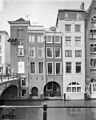
 Achtergevels - Utrecht - 20235551 - RCE.jpg 802 × 1,200; 184 KB
-
 Choorstraat 16.JPG 3,456 × 5,184; 7.05 MB
-
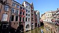
 Choorstraat18.jpg 2,000 × 3,008; 2.13 MB
-
 Exterieur GEDEELTE ACHTERGEVEL - Utrecht - 20314828 - RCE.jpg 1,200 × 1,195; 234 KB
-
 Exterieur GEDEELTE ACHTERGEVEL - Utrecht - 20314829 - RCE.jpg 1,186 × 1,200; 315 KB
-
 Exterieur OVERZICHT ACHTERGEVEL - Utrecht - 20314830 - RCE.jpg 958 × 1,200; 218 KB
-
 Exterieur OVERZICHT ACHTERGEVELS - Utrecht - 20314832 - RCE.jpg 1,200 × 960; 248 KB
-
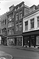
 Lange Elisabethstraat Mariaplaats, 3511 Utrecht, Netherlands - panoramio (23).jpg 2,048 × 1,155; 633 KB
-
 Voorgevels - Utrecht - 20235550 - RCE.jpg 802 × 1,200; 155 KB


.jpg)
