Category:Choi Ancestral Hall, Tin Sam Village
Jump to navigation
Jump to search
| Object location | | View all coordinates using: OpenStreetMap |
|---|
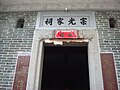
English: Choi Ancestral Hall aka. Chung Kwong Family Hall. Built around the 1920s.
中文:宗光家祠
Media in category "Choi Ancestral Hall, Tin Sam Village"
The following 3 files are in this category, out of 3 total.
-
 Tin Sam Choi Ancestral Hall1.JPG 3,264 × 2,448; 1.94 MB
-
 Tin Sam Choi Ancestral Hall2.JPG 3,264 × 2,448; 2.14 MB
-
 Tin Sam Choi Ancestral Hall3.JPG 3,264 × 2,448; 1.86 MB


