Category:Chew Stoke
Jump to navigation
Jump to search
English: Chew Stoke is a small village and civil parish in the Chew Valley, in Somerset, England, about southwest of Chew Stoke itself.
Nederlands: Chew Stoke is een plaats en civil parish in het bestuurlijke gebied Bath and North East Somerset, in het Engelse graafschap Somerset met 905 inwoners.
Polski: Chew Stoke – wieś w Anglii, w hrabstwie ceremonialnym Somerset, w dystrykcie (unitary authority) Bath and North East Somerset. Leży 12 km na południe od miasta Bristol i 176 km na zachód od Londynu. W 2001 miejscowość liczyła 905 mieszkańców.
a village located in Bath and North East Somerset, United Kingdom  | |||||
| Upload media | |||||
| Instance of | |||||
|---|---|---|---|---|---|
| Location | Bath and North East Somerset, Somerset, South West England, England | ||||
| Population |
| ||||
| Said to be the same as | Chew Stoke (Wikimedia duplicated page, civil parish) | ||||
 | |||||
Subcategories
This category has the following 4 subcategories, out of 4 total.
A
C
- Chew Stoke packhorse bridge (9 F)
- Chew Stoke rectory (7 F)
Media in category "Chew Stoke"
The following 200 files are in this category, out of 351 total.
(previous page) (next page)-
 A Christmas window scene - geograph.org.uk - 6699021.jpg 2,472 × 3,296; 2.42 MB
-
 A few steps - geograph.org.uk - 4171000.jpg 1,704 × 2,304; 1.71 MB
-
 A field with some protected trees - geograph.org.uk - 5869451.jpg 2,304 × 1,704; 1.66 MB
-
 A lakesman on Ben Bridge - geograph.org.uk - 5568421.jpg 2,304 × 1,704; 1,023 KB
-
 A light to guide the way - geograph.org.uk - 4170509.jpg 1,704 × 2,304; 2.19 MB
-
 A long ride past the lake - geograph.org.uk - 5896127.jpg 2,304 × 1,704; 1.44 MB
-
 A mark on St Andrew's - geograph.org.uk - 4168639.jpg 1,704 × 2,304; 1.99 MB
-
 A marked gateway - geograph.org.uk - 5871413.jpg 2,304 × 1,704; 1.74 MB
-
 A new outlet for The Stoke - geograph.org.uk - 6699036.jpg 3,296 × 2,472; 2.83 MB
-
 A pair of watery eyes (geograph 6699032).jpg 3,296 × 2,472; 1.76 MB
-
 A pastoral scene - geograph.org.uk - 4171011.jpg 2,304 × 1,704; 1.63 MB
-
 A patch kept for Mother Nature - geograph.org.uk - 4171040.jpg 2,304 × 1,704; 1.61 MB
-
 A return to the old ways - geograph.org.uk - 6762789.jpg 3,296 × 2,472; 3.41 MB
-
 A rubbish path - geograph.org.uk - 4171012.jpg 1,704 × 2,304; 2.1 MB
-
 A shrouding tree - geograph.org.uk - 5871452.jpg 2,304 × 1,704; 1.63 MB
-
 A sign of village life - geograph.org.uk - 4171030.jpg 2,304 × 1,704; 1.81 MB
-
 A tree with legs - geograph.org.uk - 6762794.jpg 2,472 × 3,296; 3.24 MB
-
 A village that cares - geograph.org.uk - 6699038.jpg 2,472 × 3,296; 3.04 MB
-
 A waiting seat - geograph.org.uk - 5871454.jpg 2,304 × 1,704; 1.79 MB
-
 A watery place - geograph.org.uk - 4850727.jpg 2,304 × 1,704; 2.17 MB
-
 A welcoming church - geograph.org.uk - 5871381.jpg 1,704 × 2,304; 1.9 MB
-
 Across the field to the church - geograph.org.uk - 5869441.jpg 1,704 × 2,304; 1.96 MB
-
 An approaching peloton - geograph.org.uk - 5896130.jpg 2,304 × 1,704; 1.18 MB
-
 An empty box - geograph.org.uk - 5871457.jpg 1,704 × 2,304; 1.99 MB
-
 An obvious place to park up and wait for the racers - geograph.org.uk - 5896118.jpg 2,304 × 1,704; 999 KB
-
 An original Bilbie - geograph.org.uk - 5871484.jpg 2,304 × 1,704; 1.83 MB
-
 Ancient path of scholars - geograph.org.uk - 5870314.jpg 2,304 × 1,704; 1.71 MB
-
 Angels in the architecture - geograph.org.uk - 5871463.jpg 2,304 × 1,704; 1.04 MB
-
 Angels, St Andrew's church, Chew Stoke - geograph.org.uk - 6331077.jpg 2,845 × 1,657; 256 KB
-
 Animal faces above the congregation - geograph.org.uk - 4170523.jpg 2,304 × 1,704; 1.78 MB
-
 Appealing time - geograph.org.uk - 5871468.jpg 2,304 × 1,704; 1.43 MB
-
 Approaching Long House Farm land - geograph.org.uk - 6765745.jpg 3,296 × 2,472; 3.23 MB
-
 At the heart of a village - geograph.org.uk - 4171035.jpg 2,304 × 1,704; 1.58 MB
-
 At the water's edge - geograph.org.uk - 1465176.jpg 640 × 480; 110 KB
-
 Autumn colour on Mill Lane - geograph.org.uk - 6699033.jpg 3,296 × 2,472; 1.8 MB
-
 Babylon Brook tumbles - geograph.org.uk - 6762798.jpg 2,472 × 3,296; 3.4 MB
-
 Babylon Brook waterfall - geograph.org.uk - 6762804.jpg 2,472 × 3,296; 3.41 MB
-
 Barnacle geese on Walley Bank - geograph.org.uk - 2008802.jpg 2,304 × 1,704; 1.57 MB
-
 Bars on the footpath - geograph.org.uk - 4171014.jpg 2,304 × 1,704; 1.67 MB
-

-
 Blending in with the greenery - geograph.org.uk - 5430797.jpg 2,304 × 1,704; 1.72 MB
-
 Blind Lane - geograph.org.uk - 4171044.jpg 2,304 × 1,704; 1.76 MB
-
 Blurry signage - geograph.org.uk - 5871458.jpg 1,704 × 2,304; 1.33 MB
-
 Boat bingo - geograph.org.uk - 4850672.jpg 2,304 × 1,704; 1.64 MB
-
 Boats for permit holders - geograph.org.uk - 1464429.jpg 640 × 418; 105 KB
-
 Breach Hill flush bracket - geograph.org.uk - 4910548.jpg 1,365 × 2,076; 832 KB
-
 Breach Hill spider - geograph.org.uk - 4910543.jpg 2,304 × 1,704; 1.67 MB
-
 Calming the traffic - geograph.org.uk - 4171017.jpg 2,304 × 1,704; 1.75 MB
-
 Can't see Yew - geograph.org.uk - 6699024.jpg 2,472 × 3,296; 1.83 MB
-
 Car trapped under bridge.JPG 3,456 × 2,304; 1.88 MB
-
 Catching the fallers - geograph.org.uk - 4170940.jpg 1,704 × 2,304; 1.45 MB
-
 Cattle at Rookery Farm - geograph.org.uk - 4674364.jpg 640 × 479; 69 KB
-
 Cattle crossroads - geograph.org.uk - 4850710.jpg 2,304 × 1,704; 1.65 MB
-
 Chapel chew stoke.JPG 1,233 × 728; 210 KB
-
 Chest tomb, St Andrew's churchyard, Chew Stoke (geograph 6331090).jpg 4,288 × 2,848; 1.65 MB
-
 Chew Lane - geograph.org.uk - 6331480.jpg 3,563 × 2,128; 1.05 MB
-
 Chew Lane east of Chew Stoke village - geograph.org.uk - 4751985.jpg 800 × 600; 139 KB
-
 Chew Magna , Chew Valley Lake - geograph.org.uk - 6538373.jpg 6,000 × 4,000; 5.69 MB
-
 Chew Stoke , B3114 - geograph.org.uk - 6538442.jpg 6,000 × 4,000; 6.53 MB
-
 Chew Stoke , B3114 - geograph.org.uk - 6538443.jpg 6,000 × 4,000; 6.36 MB
-
 Chew Stoke , B3114 - geograph.org.uk - 6538445.jpg 6,000 × 4,000; 7.33 MB
-
 Chew Stoke , B3114 - geograph.org.uk - 6538446.jpg 6,000 × 4,000; 7.63 MB
-
 Chew Stoke , B3114 - geograph.org.uk - 6538449.jpg 6,000 × 4,000; 6.65 MB
-
 Chew Stoke , B3114 - geograph.org.uk - 6538450.jpg 6,000 × 4,000; 6.06 MB
-
 Chew Stoke , B3114 - geograph.org.uk - 6538452.jpg 6,000 × 4,000; 7.47 MB
-
 Chew Stoke , B3114 - geograph.org.uk - 6538453.jpg 5,781 × 3,853; 4.46 MB
-
 Chew Stoke , Breach Hill Lane - geograph.org.uk - 6538433.jpg 6,000 × 4,000; 6.69 MB
-
 Chew Stoke , Breach House - geograph.org.uk - 6551355.jpg 6,000 × 4,000; 6.35 MB
-
 Chew Stoke , Chew Valley Lake - geograph.org.uk - 6524226.jpg 6,000 × 4,000; 7.62 MB
-
 Chew Stoke , Chew Valley Lake - geograph.org.uk - 6524231.jpg 4,846 × 3,231; 3.15 MB
-
 Chew Stoke , Chew Valley Lake - geograph.org.uk - 6538377.jpg 5,833 × 3,889; 4.56 MB
-
 Chew Stoke , Chew Valley Lake - geograph.org.uk - 6538378.jpg 6,000 × 4,000; 7.44 MB
-
 Chew Stoke , Chew Valley Lake - geograph.org.uk - 6538382.jpg 6,000 × 4,000; 7.91 MB
-
 Chew Stoke , Chew Valley Lake - geograph.org.uk - 6538384.jpg 4,000 × 6,000; 4.65 MB
-
 Chew Stoke , Chew Valley Lake - geograph.org.uk - 6538385.jpg 5,831 × 3,887; 4.06 MB
-
 Chew Stoke , Chew Valley Lake - geograph.org.uk - 6538387.jpg 6,000 × 4,000; 6.6 MB
-
 Chew Stoke , Chew Valley Lake - geograph.org.uk - 6538388.jpg 6,000 × 4,000; 6.76 MB
-
 Chew Stoke , Chew Valley Lake - geograph.org.uk - 6538448.jpg 6,000 × 4,000; 6.23 MB
-
 Chew Stoke , Chew Valley Lake - geograph.org.uk - 6538454.jpg 6,000 × 4,000; 6.02 MB
-
 Chew Stoke , Chew Valley Lake - geograph.org.uk - 6538455.jpg 6,000 × 4,000; 6.71 MB
-
 Chew Stoke , Country Lane - geograph.org.uk - 6538409.jpg 6,000 × 4,000; 6.45 MB
-
 Chew Stoke , Countryside Scenery - geograph.org.uk - 6538413.jpg 6,000 × 4,000; 5.8 MB
-
 Chew Stoke , Cragwood - geograph.org.uk - 6538434.jpg 6,000 × 4,000; 6.32 MB
-
 Chew Stoke , Crop Field - geograph.org.uk - 6551364.jpg 6,000 × 4,000; 7.42 MB
-
 Chew Stoke , Crop Field - geograph.org.uk - 6551375.jpg 6,000 × 4,000; 6.15 MB
-
 Chew Stoke , Crop Field - geograph.org.uk - 6551376.jpg 6,000 × 4,000; 5.85 MB
-
 Chew Stoke , Fairseat Farm - geograph.org.uk - 6538427.jpg 5,725 × 3,817; 4.69 MB
-
 Chew Stoke , Fairseat Farm - geograph.org.uk - 6538430.jpg 5,675 × 3,783; 7.76 MB
-
 Chew Stoke , Fairseat Workshops - geograph.org.uk - 6538422.jpg 6,000 × 4,000; 6.96 MB
-
 Chew Stoke , Fairseat Workshops - geograph.org.uk - 6538423.jpg 6,000 × 4,000; 7.65 MB
-
 Chew Stoke , Farm Track - geograph.org.uk - 6538435.jpg 6,000 × 4,000; 7.65 MB
-
 Chew Stoke , Footpath - geograph.org.uk - 6538391.jpg 6,000 × 4,000; 7.32 MB
-
 Chew Stoke , Footpath - geograph.org.uk - 6538403.jpg 6,000 × 4,000; 7.92 MB
-
 Chew Stoke , Footpath - geograph.org.uk - 6551345.jpg 6,000 × 4,000; 6.81 MB
-
 Chew Stoke , Footpath - geograph.org.uk - 6551346.jpg 6,000 × 4,000; 7.8 MB
-
 Chew Stoke , Footpath - geograph.org.uk - 6551358.jpg 6,000 × 4,000; 6.53 MB
-
 Chew Stoke , Grassy Field - geograph.org.uk - 6538402.jpg 6,000 × 4,000; 7.74 MB
-
 Chew Stoke , Grassy Field - geograph.org.uk - 6538410.jpg 6,000 × 4,000; 6.94 MB
-
 Chew Stoke , Grassy Field - geograph.org.uk - 6538412.jpg 6,000 × 4,000; 7.55 MB
-
 Chew Stoke , Grassy Field - geograph.org.uk - 6538415.jpg 6,000 × 4,000; 6.54 MB
-
 Chew Stoke , Grassy Field - geograph.org.uk - 6538418.jpg 6,000 × 4,000; 6.98 MB
-
 Chew Stoke , Grassy Field - geograph.org.uk - 6538420.jpg 6,000 × 4,000; 6.99 MB
-
 Chew Stoke , Grassy Field - geograph.org.uk - 6538444.jpg 6,000 × 4,000; 7.48 MB
-
 Chew Stoke , Grassy Field - geograph.org.uk - 6538447.jpg 6,000 × 4,000; 6.69 MB
-
 Chew Stoke , Grassy Field - geograph.org.uk - 6551350.jpg 6,000 × 4,000; 6.77 MB
-
 Chew Stoke , Grassy Field - geograph.org.uk - 6551361.jpg 6,000 × 4,000; 7.65 MB
-
 Chew Stoke , Grassy Field - geograph.org.uk - 6551363.jpg 6,000 × 4,000; 7.44 MB
-
 Chew Stoke , Grassy Field - geograph.org.uk - 6551377.jpg 6,000 × 4,000; 6.42 MB
-
 Chew Stoke , Grassy Field ^ Cattle - geograph.org.uk - 6551343.jpg 6,000 × 4,000; 6.5 MB
-
 Chew Stoke , Grassy Field ^ Cattle - geograph.org.uk - 6551365.jpg 6,000 × 4,000; 5.98 MB
-
 Chew Stoke , Grassy Field ^ Gate - geograph.org.uk - 6551351.jpg 6,000 × 4,000; 6.07 MB
-
 Chew Stoke , Grassy Path - geograph.org.uk - 6551360.jpg 6,000 × 4,000; 6.44 MB
-
 Chew Stoke , Lane - geograph.org.uk - 6538437.jpg 6,000 × 4,000; 6.57 MB
-
 Chew Stoke , Pumping Station Entrance - geograph.org.uk - 6538396.jpg 6,000 × 4,000; 5.89 MB
-
 Chew Stoke , Road - geograph.org.uk - 6538401.jpg 6,000 × 4,000; 7.08 MB
-
 Chew Stoke , Road - geograph.org.uk - 6538439.jpg 6,000 × 4,000; 7.08 MB
-
 Chew Stoke , Road - geograph.org.uk - 6538441.jpg 5,779 × 3,853; 7.22 MB
-
 Chew Stoke , Road - geograph.org.uk - 6538451.jpg 6,000 × 4,000; 7.49 MB
-
 Chew Stoke , Rose Cottage - geograph.org.uk - 6538438.jpg 4,737 × 3,158; 3.89 MB
-
 Chew Stoke , Royal Mail Vans - geograph.org.uk - 6538424.jpg 6,000 × 4,000; 6.57 MB
-
 Chew Stoke , Stile - geograph.org.uk - 6538419.jpg 4,000 × 6,000; 7.7 MB
-
 Chew Stoke , Stoke Hill B3114 - geograph.org.uk - 6538432.jpg 6,000 × 4,000; 7.28 MB
-
 Chew Stoke , Stonehaven - geograph.org.uk - 6551356.jpg 6,000 × 4,000; 6.51 MB
-
 Chew Stoke , Track - geograph.org.uk - 6551357.jpg 6,000 × 4,000; 6.77 MB
-
 Chew Stoke , Village Scenery - geograph.org.uk - 6538416.jpg 6,000 × 4,000; 6.28 MB
-
 Chew Stoke , Walley Lane - geograph.org.uk - 6538380.jpg 6,000 × 4,000; 6.33 MB
-
 Chew Stoke , Walley Lane - geograph.org.uk - 6538393.jpg 3,783 × 2,522; 2.73 MB
-
 Chew Stoke , Wallycourt Road - geograph.org.uk - 6538392.jpg 6,000 × 4,000; 6.52 MB
-
 Chew Stoke , Wallycourt Road - geograph.org.uk - 6538397.jpg 6,000 × 4,000; 7.73 MB
-
 Chew Stoke , Wallycourt Road - geograph.org.uk - 6538398.jpg 6,000 × 4,000; 7.56 MB
-
 Chew Stoke , Wallycourt Road - geograph.org.uk - 6538404.jpg 6,000 × 4,000; 6.6 MB
-
 Chew Stoke , Wallycourt Road - geograph.org.uk - 6538406.jpg 6,000 × 4,000; 6.42 MB
-
 Chew Stoke , Wallycourt Road - geograph.org.uk - 6538407.jpg 6,000 × 4,000; 6.88 MB
-
 Chew Stoke Bowling Club - geograph.org.uk - 4171022.jpg 2,304 × 1,704; 1.47 MB
-
 Chew Stoke Brook - geograph.org.uk - 6331554.jpg 4,251 × 2,523; 1.29 MB
-
 Chew Stoke Brook - geograph.org.uk - 6331558.jpg 2,848 × 4,288; 2.01 MB
-
 Chew Stoke Brook - geograph.org.uk - 6331563.jpg 2,848 × 4,288; 1.84 MB
-
 Chew Stoke church from the farmland - geograph.org.uk - 6765748.jpg 3,296 × 2,472; 3.59 MB
-
 Chew Stoke Church School - geograph.org.uk - 5870308.jpg 1,704 × 2,304; 1.66 MB
-
 Chew Stoke cricket field - geograph.org.uk - 1997378.jpg 1,024 × 768; 128 KB
-
 Chew Stoke cricket pavilion - geograph.org.uk - 1997391.jpg 1,024 × 768; 189 KB
-
 Chew Stoke ford - geograph.org.uk - 4170946.jpg 2,304 × 1,704; 1.74 MB
-
 Chew Stoke Methodist Church - geograph.org.uk - 4171005.jpg 1,704 × 2,304; 1.73 MB
-
 Chew Stoke millennium sign - geograph.org.uk - 4171033.jpg 1,704 × 2,304; 1.36 MB
-
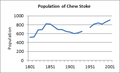
 Chew Stoke Population.PNG 909 × 624; 13 KB
-
 Chew Stoke village sign.JPG 860 × 2,402; 396 KB
-
 Chew tower - geograph.org.uk - 5430944.jpg 1,704 × 2,304; 1.49 MB
-
 Chew Valley Lake - geograph.org.uk - 5787435.jpg 1,600 × 900; 204 KB
-
 Chew Valley Rugby - panoramio.jpg 2,304 × 1,728; 500 KB
-
 Chewstokebridge.JPG 576 × 432; 64 KB
-
 Chewstokebridge2.JPG 1,114 × 636; 159 KB
-
 Chewstokebridges.JPG 1,280 × 960; 344 KB
-
 ChewStokePop.png 326 × 199; 6 KB
-
 Chewstokeschool2.JPG 1,280 × 960; 317 KB
-
 Chewstokevillagescape.JPG 2,418 × 1,527; 1,010 KB
-
 Chillyhill Lane - geograph.org.uk - 5445732.jpg 2,304 × 1,704; 1.77 MB
-
 Church Farm, Chew Stoke (geograph 6331306).jpg 4,139 × 2,540; 1.63 MB
-
 Church hall, Chew Stoke - geograph.org.uk - 6331341.jpg 3,818 × 2,563; 1.7 MB
-
 Church hall, Chew Stoke - geograph.org.uk - 6331566.jpg 2,572 × 1,582; 1.03 MB
-
 Church Lane, Chew Stoke - geograph.org.uk - 6331316.jpg 4,288 × 2,848; 2.09 MB
-
 Church Lane, Chew Stoke - geograph.org.uk - 6331326.jpg 4,288 × 2,848; 2.13 MB
-
 Closed, but inaccessible - geograph.org.uk - 4850629.jpg 2,304 × 1,704; 1.67 MB
-
 Clouds over Blackdown - geograph.org.uk - 4850690.jpg 2,304 × 1,704; 1.55 MB
-
 Commemorative plaque - geograph.org.uk - 2007744.jpg 1,704 × 2,304; 1.76 MB
-
 Commemorative plaque and flagpole - geograph.org.uk - 2007117.jpg 1,704 × 2,304; 1.1 MB
-
 Compton Martin , Countryside Scenery - geograph.org.uk - 6551367.jpg 6,000 × 4,000; 3.43 MB
-
 Compton Martin , Countryside Scenery - geograph.org.uk - 6551372.jpg 6,000 × 4,000; 5.9 MB
-
 Compton Martin , Grassy Field - geograph.org.uk - 6551369.jpg 6,000 × 4,000; 6.69 MB
-
 Converted farm building, Chew Stoke - geograph.org.uk - 6331278.jpg 3,623 × 2,512; 1.33 MB
-
 Cottages, Pagans Hill - geograph.org.uk - 6330918.jpg 3,082 × 1,567; 384 KB
-
 Crossroads, Chew Stoke - geograph.org.uk - 6331472.jpg 4,288 × 2,848; 1.18 MB
-
 Cycling signpost by the Methodist church - geograph.org.uk - 6699037.jpg 3,296 × 2,472; 1.75 MB
-
 Dairy Way, Chew Stoke - geograph.org.uk - 6331524.jpg 4,270 × 2,704; 1.8 MB
-
 Dawn over Chew Valley Lake - geograph.org.uk - 5683831.jpg 1,024 × 680; 210 KB
-
 Disused agricultural building-barn - geograph.org.uk - 5032205.jpg 3,648 × 2,048; 2.75 MB
-
 Drier than for some time - geograph.org.uk - 5870304.jpg 1,704 × 2,304; 2.2 MB
-
 Edge of Herons Green Bay, Chew Valley Lake - geograph.org.uk - 6258923.jpg 5,184 × 3,456; 5.89 MB
-
 Evening roost - geograph.org.uk - 2007756.jpg 2,304 × 1,704; 1.59 MB
-
 Exit from the layby - geograph.org.uk - 2523634.jpg 640 × 480; 135 KB
-
 Fairseats.JPG 1,129 × 772; 217 KB
-
 Farm road - geograph.org.uk - 5445480.jpg 1,704 × 2,304; 1.88 MB
-
 Farmland east of Chew Stoke - geograph.org.uk - 6331531.jpg 4,288 × 2,848; 1.69 MB
-
 Fields Above Chew Valley Reservoir - geograph.org.uk - 4601010.jpg 640 × 428; 69 KB
-
 Fishers only - geograph.org.uk - 4850626.jpg 2,304 × 1,704; 1.66 MB
-
 Fishers only^ - geograph.org.uk - 2007779.jpg 1,704 × 2,304; 2.08 MB
-
 Fishing for worms^ - geograph.org.uk - 1465220.jpg 640 × 480; 108 KB
-
 Fly fishing lesson, Woodford Lodge - geograph.org.uk - 1464419.jpg 640 × 435; 103 KB
-
 Font, St Andrew's church, Chew Stoke - geograph.org.uk - 6331071.jpg 3,345 × 2,748; 532 KB
-
 Footbridge - panoramio (1).jpg 2,592 × 1,944; 2.38 MB
-
 Footpath near Pagans Hill - geograph.org.uk - 6330930.jpg 4,288 × 2,848; 1.71 MB
-
 Ford at Chew Stoke - geograph.org.uk - 4684422.jpg 6,000 × 4,000; 6.28 MB
-
 Ford at Chew Stoke - geograph.org.uk - 4684429.jpg 6,000 × 4,000; 6.27 MB
-
 Getting to the station - geograph.org.uk - 5568428.jpg 2,304 × 1,704; 1.68 MB
-
 Good year for the weed - geograph.org.uk - 4170945.jpg 1,704 × 2,304; 1.72 MB
-
 Green and still - geograph.org.uk - 5430815.jpg 2,304 × 1,704; 1.76 MB
-
 Greenery under the pack horse bridge - geograph.org.uk - 5871428.jpg 2,304 × 1,704; 1.78 MB
-
 Heron's Green Bay - geograph.org.uk - 2017287.jpg 640 × 480; 48 KB
-
 Herons Green - geograph.org.uk - 2662283.jpg 2,592 × 1,944; 1.37 MB
-
 Herons Green Bay, Chew Valley Lake - geograph.org.uk - 6258906.jpg 5,184 × 3,456; 6.61 MB
-
 House near the lake - geograph.org.uk - 2523637.jpg 640 × 480; 120 KB


.jpg)


.jpg)


.jpg)


.jpg)


