Category:Che Pau Teng
Jump to navigation
Jump to search
| Object location | | View all coordinates using: OpenStreetMap |
|---|
English: Che Pau Teng. Hill on Stanley Peninsula, Southern District, Hong Kong. Altitude: 177m.
中文:斜炮頂
Media in category "Che Pau Teng"
The following 8 files are in this category, out of 8 total.
-
 St. Stephen's Beach overview 201111.JPG 3,648 × 2,736; 3.13 MB
-
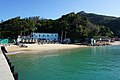 St. Stephen's Beach Water Sports Centre (blue sky).jpg 6,000 × 4,000; 13.46 MB
-
 Stanley Bay and Murray House.jpg 604 × 453; 52 KB
-
 Stanley Bay, Mar 06.JPG 1,600 × 1,200; 430 KB
-
 Stanley Peninsula.jpg 977 × 752; 165 KB
-
 Stanley seabeach-1.JPG 1,024 × 626; 98 KB
-
 The Twins.jpg 960 × 574; 94 KB
-
 Tsui Wah Ferry Po Toi.JPG 3,264 × 2,448; 2.85 MB

.jpg)


