Category:Chattahoochee River
Jump to navigation
Jump to search
river in the United States | |||||
| Upload media | |||||
| Instance of | |||||
|---|---|---|---|---|---|
| Location | Alabama | ||||
| Length |
| ||||
| Mouth of the watercourse | |||||
| Drainage basin | |||||
| Tributary |
| ||||
 | |||||
Subcategories
This category has the following 12 subcategories, out of 12 total.
B
- Buford Dam (3 F)
C
- Chattahoochee Nature Center (13 F)
J
- Jim Woodruff Dam (14 F)
L
- Langdale Dam (1 F)
R
- Riverview Dam (1 F)
W
Media in category "Chattahoochee River"
The following 55 files are in this category, out of 55 total.
-
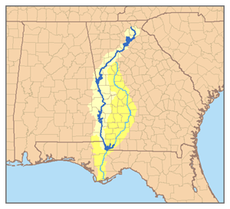
Chattahoochee watershed.png 300 × 273; 100 KB
-
2021-03-08 Salem, AL - Moffit's Mill on Uchee Creek.jpg 2,688 × 4,032; 8.52 MB
-
Bennett Smith.jpg 4,096 × 2,730; 3.28 MB
-
Busy-Landing-Chattahoochee-NPS.jpg 450 × 300; 42 KB
-
Chattahoochee Nature Center Sign.webp 4,722 × 3,142; 16.32 MB
-
Chattahoochee River - Jones Bridge Park.jpg 450 × 337; 125 KB
-
Citymillsdam2.JPG 401 × 302; 42 KB
-
Confederate cannon at C.S.S. Muscogee and Chattahoochee gunboats 70000212.jpg 1,024 × 683; 1.01 MB
-
Eagleandphenixdam.JPG 498 × 348; 78 KB
-
Early County line, Georgia State border, US84EB.JPG 4,608 × 3,456; 5.45 MB
-
Earnest Vandiver Causeway sign.JPG 4,320 × 3,240; 4.47 MB
-
East Palisades.JPG 3,239 × 2,429; 3.86 MB
-
EastPalisades2CRNRADec10 2011.jpg 2,064 × 795; 580 KB
-
EastPalisades3CRNRADec10 2011.jpg 2,592 × 1,936; 2.66 MB
-
EastPalisades4CRNRADec10 2011.jpg 2,592 × 1,936; 2.12 MB
-
EastPalisades5CRNRADec10 2011.jpg 3,056 × 799; 686 KB
-
EastPalisades7CRNRADec10 2011.jpg 2,592 × 1,936; 1.71 MB
-
EastPalisadesCRNRADec10 2011.jpg 2,592 × 1,936; 1.92 MB
-
EastPalisadesCRNRADeck.jpg 2,587 × 1,923; 1.93 MB
-
Eufaula AL-Walter F George Lake-Georgetown GA from airplane.jpg 3,072 × 2,304; 1.47 MB
-
Eurycea guttoli(1).jpg 500 × 383; 164 KB
-
Fall at the Chattahoochee River.jpg 3,872 × 2,592; 9.33 MB
-
Fall at the ChattahoocheeRiver.jpg 3,586 × 2,394; 8.32 MB
-
Fall-View-West-Chattahoochee-NPS.jpg 450 × 300; 75 KB
-
Fort Hull map.jpg 1,384 × 735; 153 KB
-
From the bridge at the Roswell Mill.jpg 3,888 × 2,592; 4.61 MB
-
Georgia State Line, US82 EB.JPG 4,320 × 3,240; 4.5 MB
-
Georgia's Rivers and Geological Regions.jpg 960 × 720; 48 KB
-
GoldBranch2CRNRAFeb262012.jpg 2,581 × 1,921; 2.17 MB
-
GoldBranch3CRNRAFeb262012.jpg 2,592 × 1,936; 2.84 MB
-
GoldBranchCRNRAFeb262012.jpg 2,577 × 1,925; 2.67 MB
-
Island Ford.jpg 2,592 × 1,936; 2.29 MB
-
IslandFord10CRNRAJan13 2012.jpg 1,936 × 2,592; 2.86 MB
-
IslandFord11CRNRAJan13 2012.jpg 2,592 × 1,936; 2.64 MB
-
IslandFord12CRNRAJan13 2012.jpg 2,592 × 1,936; 1.81 MB
-
IslandFord13CRNRAJan13 2012.jpg 2,587 × 1,922; 2.27 MB
-
IslandFord14CRNRAJan13 2012.jpg 2,592 × 1,936; 2.43 MB
-
IslandFord15CRNRAJan13 2012.jpg 1,936 × 2,592; 2.92 MB
-
IslandFord16CRNRAJan13 2012.jpg 1,931 × 2,586; 3.25 MB
-
IslandFord17CRNRAJan13 2012.jpg 1,923 × 2,582; 3.16 MB
-
IslandFord18CRNRAJan13 2012.jpg 2,592 × 1,936; 2.94 MB
-
IslandFord19CRNRAJan13 2012.jpg 2,592 × 1,936; 3.21 MB
-
IslandFord20CRNRAJan13 2012.jpg 2,586 × 1,906; 3.17 MB
-
IslandFord21CRNRAJan13 2012.jpg 1,931 × 2,586; 2.45 MB
-
IslandFord2CRNRAJan13 2012.jpg 2,592 × 1,936; 2.87 MB
-
IslandFord4CRNRAJan13 2012.jpg 2,588 × 1,924; 2.36 MB
-
IslandFord5CRNRAJan13 2012.jpg 1,936 × 2,592; 2.88 MB
-
IslandFord6CRNRAJan13 2012.jpg 2,592 × 1,936; 2.77 MB
-
IslandFord7CRNRAJan13 2012.jpg 2,592 × 1,936; 2.43 MB
-
Powerlines Crossing Chattahoochee River (40207555290).jpg 2,400 × 1,600; 2.69 MB
-
RAFTING ON THE CHATTAHOOCHEE RIVER - NARA - 545937.jpg 3,000 × 2,024; 977 KB
-
South bank of Chattahoochee River, 1864 - NARA - 528890.jpg 3,000 × 2,402; 1.56 MB
-
South bank of Chattahoochee River, 1864 - NARA - 528890.tif 3,000 × 2,402; 6.87 MB
-
VickeryCreek0131.jpg 5,183 × 2,007; 1.54 MB
-
Watersheds of the Apalachicola and Altamaha rivers.jpg 600 × 781; 449 KB


