Category:Charles Lane (Manhattan)
Jump to navigation
Jump to search
English: Charles Lane, a brick, alley-like street running between West Street (West Side Highway/NY 9A) and Washington Street, a half block north of parallel Charles Street, in the Greenwich Village neighborhood of Manhattan in New York City
| Object location | | View all coordinates using: OpenStreetMap |
|---|
Subcategories
This category has only the following subcategory.
Media in category "Charles Lane (Manhattan)"
The following 3 files are in this category, out of 3 total.
-
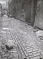 Charles Lane, between West and Washington Streets, Manhattan (NYPL b13668355-482711).jpg 1,875 × 2,548; 1.2 MB
-
 Charles Lane, between West and Washington Streets, Manhattan (NYPL b13668355-482711).tiff 2,320 × 3,072; 20.42 MB
-
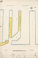 Sanborn Manhattan V. 3 Plate 47 publ. 1904.jpg 4,362 × 6,594; 2.99 MB
.jpg)
