Category:Charing Heath
Jump to navigation
Jump to search
English: Charing Heath is a village in the civil parish of Charing, in the Ashford district, in the county of Kent, England.
village in Kent, England, UK | |||||
| Upload media | |||||
| Instance of | |||||
|---|---|---|---|---|---|
| Location | Charing, Ashford, Kent, South East England, England | ||||
 | |||||
Subcategories
This category has the following 2 subcategories, out of 2 total.
R
Media in category "Charing Heath"
The following 11 files are in this category, out of 11 total.
-
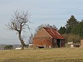 Barn at Charing Heath - geograph.org.uk - 1141712.jpg 640 × 480; 143 KB
-

-
 Charing Heath Recreation Ground - geograph.org.uk - 3321907.jpg 640 × 426; 56 KB
-
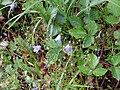 Harebells (Campanula rotundifolia) - geograph.org.uk - 229841.jpg 640 × 480; 136 KB
-
 Holy Trinity churchyard - geograph.org.uk - 229820.jpg 640 × 481; 129 KB
-
 House by Egerton Rd - geograph.org.uk - 3321912.jpg 640 × 426; 62 KB
-
 House on Egerton Rd - geograph.org.uk - 3321904.jpg 640 × 426; 91 KB
-
 Houses on Egerton Rd - geograph.org.uk - 3321906.jpg 640 × 426; 73 KB
-
 Magritte seen in Kent countryside - geograph.org.uk - 229803.jpg 640 × 480; 56 KB
-
 Old School House - geograph.org.uk - 229823.jpg 640 × 480; 138 KB
-
 Pollarded trees, Charing Heath - geograph.org.uk - 1141688.jpg 640 × 480; 186 KB


_-_geograph.org.uk_-_229841.jpg)


