Category:Chapelle des soeurs in Dienville
Jump to navigation
Jump to search
| Object location | | View all coordinates using: OpenStreetMap |
|---|
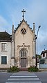
Français : "La chapelle des soeurs", 7 rue Grégoire Royer à Dienville
chapel located in Aube, in France  | |||||
| Upload media | |||||
| Instance of | |||||
|---|---|---|---|---|---|
| Location | Dienville, Aube, Grand Est, Metropolitan France, France | ||||
 | |||||
Media in category "Chapelle des soeurs in Dienville"
The following 4 files are in this category, out of 4 total.
-
 Chapelle des soeurs in Dienville 01.jpg 3,070 × 4,890; 7.61 MB
-
 Chapelle des soeurs in Dienville 02.jpg 3,211 × 5,656; 9.41 MB
-
 Chapelle des soeurs in Dienville 03.jpg 3,532 × 5,408; 12.14 MB
-
 Chapelle des soeurs in Dienville 04.jpg 3,253 × 4,921; 8.59 MB


