Category:Chapelle Sainte-Anne de Penchâteau (Le Pouliguen)
Jump to navigation
Jump to search
| Object location | | View all coordinates using: OpenStreetMap |
|---|
|
This building is inscrit au titre des monuments historiques de la France. It is indexed in the base Mérimée, a database of architectural heritage maintained by the French Ministry of Culture, under the reference PA00108779
|
chapel in Le Pouliguen, France  | |||||
| Upload media | |||||
| Instance of | |||||
|---|---|---|---|---|---|
| Dedicated to | |||||
| Made from material | |||||
| Location | Penchâteau, Le Pouliguen, Loire-Atlantique, Pays de la Loire, Metropolitan France, France | ||||
| Architectural style | |||||
| Diocese | |||||
| Owned by | |||||
| Heritage designation |
| ||||
| Inception |
| ||||
| Religion or worldview | |||||
 | |||||
Media in category "Chapelle Sainte-Anne de Penchâteau (Le Pouliguen)"
The following 10 files are in this category, out of 10 total.
-
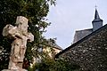 Chapelle Sainte-Anne & Croix de Penchâteau - Le Pouliguen.JPG 4,576 × 3,056; 4.06 MB
-
 Chapelle Sainte-Anne de Penchâteau - Le Pouliguen - Retable.JPG 3,011 × 4,545; 2.03 MB
-
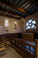
 Chapelle Sainte-Anne de Penchâteau - Le Pouliguen - Stained Glass.JPG 2,999 × 4,539; 1.46 MB
-
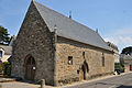
 Chapelle Sainte-Anne de Penchâteau 2.jpg 2,716 × 4,196; 2.73 MB
-
 Chapelle Sainte-Anne de Penchâteau.jpg 2,785 × 4,288; 1.96 MB
-
 Chapelle Sainte-Anne Penchâteau.jpg 2,515 × 2,726; 1.95 MB
-
 Le Pouliguen chapelle de Penchâteau 1.jpg 1,424 × 2,144; 2.07 MB
-
 Le Pouliguen chapelle de Penchâteau 2.jpg 2,136 × 1,424; 2.19 MB
-
 Le Pouliguen chapelle de Penchâteau 3.jpg 1,424 × 2,144; 2.05 MB
-
 Le Pouliguen chapelle de Penchâteau 4.jpg 2,136 × 1,424; 2.64 MB


