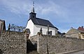
Category:Chapelle Saint-Willibrord (Abweiler)
Jump to navigation
Jump to search
| Object location | | View all coordinates using: OpenStreetMap |
|---|
 | |||||
| Upload media | |||||
| Instance of | |||||
|---|---|---|---|---|---|
| Location | Abweiler, Bettembourg, Canton of Esch-sur-Alzette, Luxembourg | ||||
 | |||||
Media in category "Chapelle Saint-Willibrord (Abweiler)"
The following 3 files are in this category, out of 3 total.
-
 Abweiler42w.jpg 1,605 × 1,039; 225 KB
-
 Kapelle Abweiler 01.jpg 1,386 × 2,015; 1.65 MB
-
 Kierch a Kierfecht Abweiler (Obeler)-101.jpg 4,076 × 2,707; 6.72 MB

-101.jpg)