Category:Chapelle Saint-Eloi (Erpeldange, Wiltz)
Jump to navigation
Jump to search
| Object location | | View all coordinates using: OpenStreetMap |
|---|
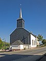
church building in Luxembourg _01.jpg)  | |||||
| Upload media | |||||
| Instance of | |||||
|---|---|---|---|---|---|
| Location |
| ||||
 | |||||
Media in category "Chapelle Saint-Eloi (Erpeldange, Wiltz)"
The following 5 files are in this category, out of 5 total.
-
 Erpeldange, kapel in straatzicht foto4 2014-06-13 15.33.jpg 4,090 × 3,068; 8.04 MB
-
 Kapelle Erpeldange (Eschweiler) 01.jpg 2,627 × 1,795; 3.51 MB
-
 Kapelle Erpeldange (Eschweiler) 02.jpg 1,880 × 2,508; 3.13 MB
-
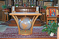 KIE Erpeldeng Eschweiler Altor.JPG 3,316 × 2,183; 2.13 MB
-
 KierIerpEsc22.JPG 1,893 × 2,075; 226 KB

_02.jpg)
