Category:Chapelle Saint-Aubin (Savelborn)
Jump to navigation
Jump to search
| Object location | | View all coordinates using: OpenStreetMap |
|---|
 | |||||
| Upload media | |||||
| Instance of | |||||
|---|---|---|---|---|---|
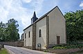
| Location | Savelborn, Waldbillig, Canton of Echternach, Luxembourg | ||||
 | |||||
Media in category "Chapelle Saint-Aubin (Savelborn)"
The following 3 files are in this category, out of 3 total.
-
 Kapelle Savelborn 01.jpg 2,685 × 1,750; 3.48 MB
-
 Kapelle Savelborn 02.jpg 1,810 × 2,601; 3.12 MB
-
 Vallée de l'Ernz, Savelborn (104).jpg 3,911 × 2,201; 1.96 MB

.jpg)