Category:Chapelle Saint-Étienne de Guer
Jump to navigation
Jump to search
| Object location | | View all coordinates using: OpenStreetMap |
|---|
|
This building is classé au titre des monuments historiques de la France. It is indexed in the base Mérimée, a database of architectural heritage maintained by the French Ministry of Culture, under the reference PA00091244
|
| Object location | | View all coordinates using: OpenStreetMap |
|---|
chapel located in Morbihan, in France  | |||||
| Upload media | |||||
| Instance of | |||||
|---|---|---|---|---|---|
| Location | Guer, Morbihan, Brittany, Q88521114, Metropolitan France, France | ||||
| Street address |
| ||||
| Heritage designation |
| ||||
 | |||||
Media in category "Chapelle Saint-Étienne de Guer"
The following 9 files are in this category, out of 9 total.
-
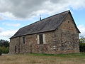 Chapelle Saint-Étienne de Guer 01.JPG 3,264 × 2,448; 2.65 MB
-
 Chapelle Saint-Étienne de Guer 02.JPG 3,264 × 2,448; 2.48 MB
-
 Chapelle Saint-Étienne de Guer 03.JPG 3,264 × 2,448; 2.72 MB
-
 Chapelle Saint-Étienne de Guer 04.JPG 2,448 × 3,264; 2.28 MB
-
 Chapelle Saint-Étienne de Guer 05.JPG 2,448 × 3,264; 2.05 MB
-
 Chapelle St Etienne.JPG 2,896 × 1,936; 2.89 MB
-
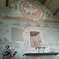 Peintures Prieuré Saint-Etienne.jpg 640 × 640; 89 KB
-
 Retable - Prieuré St Etienne.jpg 640 × 640; 84 KB
-
 Sculpture Saint-Etienne.jpg 640 × 640; 81 KB


