Category:Chapel of Saint Anne (Darkov)
Jump to navigation
Jump to search
| Object location | | View all coordinates using: OpenStreetMap |
|---|
.JPG) | |||||
| Upload media | |||||
| Instance of | |||||
|---|---|---|---|---|---|
| Dedicated to | |||||
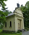
| Location | Lázeňský park, Darkov, Karviná, Karviná District, Moravian-Silesian Region, Czechia | ||||
| Architectural style | |||||
| Diocese | |||||
| Heritage designation |
| ||||
| Inception |
| ||||
| Religion or worldview | |||||
 | |||||
Media in category "Chapel of Saint Anne (Darkov)"
The following 17 files are in this category, out of 17 total.
-
 CZE Karviná, Darkov, kaple sv. Anny.jpg 2,453 × 3,123; 2.62 MB
-
 Kaple sv. Anny, Darkov (2).jpg 2,189 × 1,451; 1,006 KB
-
 Kaple sv. Anny, Darkov (3).jpg 2,256 × 1,496; 1.69 MB
-
 Kaple sv. Anny, Darkov (4).jpg 2,256 × 1,496; 1.69 MB
-
 Kaple sv. Anny, Darkov, vrch.JPG 3,336 × 4,195; 5.41 MB
-
 Kaple sv. Anny, Darkov.jpg 2,256 × 1,496; 1.65 MB
-
 Kaple sv. Anny, Mariánský sloup, Darkov,.jpg 2,256 × 1,496; 1.71 MB
-
 Kaple sv. Anny, zvon, Darkov.jpg 2,256 × 1,496; 1.26 MB
-
 Kaple sv.Anny - panoramio.jpg 2,288 × 1,712; 839 KB
-
 Kaplica św. Anny w Darkowie.jpg 2,992 × 4,000; 1.2 MB
-
 Karviná, Darkov, kaple sv. Anny (1).JPG 2,625 × 3,242; 4.19 MB
-
 Karviná, Darkov, kaple sv. Anny (2).JPG 2,656 × 3,802; 5.26 MB
-
 Karviná, Darkov, kaple sv. Anny (3).JPG 3,331 × 2,624; 3.78 MB
-
 Karviná, Darkov, kaple sv. Anny (4).JPG 2,807 × 3,796; 6.04 MB
-
 Karviná, Darkov, kaple sv. Anny (5).JPG 3,337 × 2,700; 4.89 MB
-
 Karviná, Darkov, kaple sv. Anny (6).JPG 3,158 × 2,641; 3.76 MB
-
 Karviná, Darkov, kaple sv. Anny (7).JPG 2,860 × 3,928; 5.85 MB

.jpg)
.jpg)
.jpg)


.JPG)
.JPG)
.JPG)
.JPG)
.JPG)
.JPG)