Category:Chapel in Żory-Rowień
Jump to navigation
Jump to search
| Object location | | View all coordinates using: OpenStreetMap |
|---|
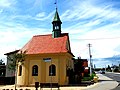
Polski: Kaplica z roku 1864 - Żory – Rowień, ulica Rybnicka u wylotu ulicy Wiejskiej
historic chapel in Żory, Silesian Voivodeship, Poland  | |||||
| Upload media | |||||
| Instance of | |||||
|---|---|---|---|---|---|
| Location | Żory, Silesian Voivodeship, Poland | ||||
| Street address |
| ||||
| Heritage designation |
| ||||
| Inception |
| ||||
| Elevation above sea level |
| ||||
 | |||||
Media in category "Chapel in Żory-Rowień"
The following 17 files are in this category, out of 17 total.
-
 Kaplica w Rowniu 01.JPG 3,456 × 4,608; 1.5 MB
-
 Kaplica w Rowniu 02.JPG 4,608 × 3,456; 1.08 MB
-
 Kaplica w Rowniu 03.JPG 4,608 × 3,456; 1.38 MB
-
 Kaplica w Rowniu 04.JPG 3,456 × 4,608; 1.36 MB
-
 Kaplica w Rowniu 05.JPG 4,608 × 3,456; 1.75 MB
-
 Kaplica w Rowniu 06.JPG 4,608 × 3,456; 1.45 MB
-
 Kapliczka w Rowniu 01.JPG 4,608 × 3,456; 940 KB
-
 Kapliczka w Rowniu 02.JPG 3,456 × 4,608; 1.17 MB
-
 Kapliczka w Rowniu 03.JPG 3,456 × 4,608; 1.36 MB
-
 Kapliczka w Rowniu 04.JPG 4,608 × 3,456; 1.36 MB
-
 Kapliczka w Rowniu 05.JPG 3,456 × 4,608; 1.19 MB
-
 Kapliczka w Rowniu 06.JPG 4,608 × 3,456; 1.84 MB
-
 Kapliczka w Rowniu 07.JPG 3,456 × 4,608; 1.91 MB
-
 Otwarta raz w roku właśnie w tym dniu 01.JPG 4,608 × 3,456; 1.37 MB
-
 Otwarta raz w roku właśnie w tym dniu 02.JPG 3,456 × 4,608; 1.36 MB
-
 Otwarta raz w roku właśnie w tym dniu 03.JPG 4,608 × 3,456; 954 KB
-
 Otwarta raz w roku właśnie w tym dniu 04.JPG 4,608 × 3,456; 1.45 MB


