Category:Challacombe
Jump to navigation
Jump to search
English: Challacombe is a small village on the edge of The Exmoor National Park, in Devon. The village has a small general shop with petrol pumps outside and a single pub, the Black Venus. The whole village is set upon one road and is close to Simonsbath.
village in United Kingdom  | |||||
| Upload media | |||||
| Instance of | |||||
|---|---|---|---|---|---|
| Location | North Devon, Devon, South West England, England | ||||
 | |||||
Subcategories
This category has the following 3 subcategories, out of 3 total.
Media in category "Challacombe"
The following 200 files are in this category, out of 294 total.
(previous page) (next page)-

-
 A footbridge over the river Bray at Challacombe - geograph.org.uk - 3917922.jpg 3,648 × 2,736; 4.92 MB
-
 A ford through the river Bray at Challacombe - geograph.org.uk - 3917924.jpg 3,648 × 2,736; 5.03 MB
-
 A ford through the river Bray at Challacombe - geograph.org.uk - 3917928.jpg 3,515 × 2,636; 4.64 MB
-
 A lone, windswept tree, by North Lane - geograph.org.uk - 6400151.jpg 1,600 × 1,198; 792 KB
-
 A399 between the farms at Westland and Little Rowley - geograph.org.uk - 5686602.jpg 1,600 × 1,200; 611 KB
-
 Abandoned muck spreader at Brockenbarrow Farm - geograph.org.uk - 4828714.jpg 1,024 × 782; 307 KB
-
-
 Archaeological survey, Chapman Barrows - geograph.org.uk - 4151674.jpg 1,024 × 768; 110 KB
-
 Archaeological survey, Chapman Barrows - geograph.org.uk - 4151686.jpg 1,024 × 768; 138 KB
-

-
 Barton Lane - geograph.org.uk - 4828934.jpg 1,024 × 873; 219 KB
-
 Barton Town Farm - geograph.org.uk - 4828953.jpg 1,024 × 780; 166 KB
-
 Beer garden of the Black Venus - geograph.org.uk - 5818090.jpg 6,000 × 4,000; 7.53 MB
-
 Boundary hedge on Chapman Barrows - geograph.org.uk - 4151785.jpg 1,024 × 768; 164 KB
-
 Boundary on Challacombe Common - geograph.org.uk - 4150985.jpg 1,024 × 768; 186 KB
-
 Boundary on Chapman Barrows - geograph.org.uk - 4151660.jpg 1,024 × 768; 255 KB
-
 Boundary wall by Chapman Barrows - geograph.org.uk - 5817849.jpg 6,000 × 4,000; 4.34 MB
-
 Bray Reservoir - geograph.org.uk - 4150965.jpg 1,024 × 768; 176 KB
-
 Bray Reservoir near the source of the river Bray - geograph.org.uk - 3917949.jpg 6,000 × 4,000; 4.94 MB
-
 Bray Reservoir, viewed from Swincombe Rocks - geograph.org.uk - 4150566.jpg 1,024 × 768; 207 KB
-
 Bridge over part of Wistlandpound Reservoir - geograph.org.uk - 2660761.jpg 1,024 × 768; 342 KB
-
 Bridge over River Bray at Challacombe Cross - geograph.org.uk - 6399513.jpg 1,600 × 1,067; 646 KB
-
 Bridleway to Parracombe - geograph.org.uk - 737925.jpg 640 × 480; 103 KB
-
 Bridleway to Parracombe Common - geograph.org.uk - 4151853.jpg 1,024 × 768; 172 KB
-
 Bridleway to Twineford - geograph.org.uk - 4828875.jpg 1,024 × 774; 203 KB
-
 Brockenbarrow Farm - geograph.org.uk - 4828690.jpg 1,024 × 768; 229 KB
-
 Brockenbarrow Farm - geograph.org.uk - 731627.jpg 464 × 640; 139 KB
-
 Brown cows near Barton Gate - geograph.org.uk - 5818368.jpg 6,000 × 4,000; 5.08 MB
-
 Buscombe Lane - geograph.org.uk - 3673330.jpg 1,024 × 768; 221 KB
-

-
 Celandines growing beside the B3358 near North Barton - geograph.org.uk - 3928056.jpg 5,278 × 3,648; 4.88 MB
-
 Challacombe Bridge on the river Bray - geograph.org.uk - 3917897.jpg 3,648 × 2,736; 5.02 MB
-
 Challacombe Bridge on the river Bray - geograph.org.uk - 3917904.jpg 3,648 × 2,736; 5.3 MB
-
 Challacombe Common - geograph.org.uk - 4151800.jpg 1,024 × 768; 146 KB
-
 Challacombe Common - geograph.org.uk - 5815479.jpg 6,000 × 4,000; 7.03 MB
-
 Challacombe Cross - geograph.org.uk - 6399511.jpg 1,600 × 1,200; 660 KB
-
 Challacombe Ford - geograph.org.uk - 4193571.jpg 3,872 × 2,592; 5.26 MB
-
 Challacombe Methodist Church - geograph.org.uk - 558381.jpg 640 × 480; 64 KB
-

-

-
 Challacombe Reservoir - geograph.org.uk - 732206.jpg 640 × 426; 74 KB
-
 Challacombe, Barton Town - geograph.org.uk - 58601.jpg 640 × 427; 109 KB
-
 Challacombe, by Brockenbarrow Farm - geograph.org.uk - 165860.jpg 640 × 427; 108 KB
-
 Challacombe, by Friendship Farm - geograph.org.uk - 165861.jpg 640 × 427; 122 KB
-
 Challacombe, by Westland Farm - geograph.org.uk - 165862.jpg 640 × 427; 118 KB
-
 Challacombe, by Yelland Cross - geograph.org.uk - 165859.jpg 640 × 427; 133 KB
-
 Challacombe, Challacombe Mill site - geograph.org.uk - 58606.jpg 640 × 427; 151 KB
-
 Challacombe, near Barton Gate - geograph.org.uk - 165857.jpg 640 × 427; 120 KB
-
 Challacombe, Old Close Bottom - geograph.org.uk - 165856.jpg 640 × 427; 165 KB
-
 Challacombe, Shoulsbury Castle - geograph.org.uk - 271714.jpg 640 × 427; 120 KB
-
-
 Challacombe, South Regis Common - geograph.org.uk - 165855.jpg 640 × 427; 118 KB
-
 Challacombe, Two Gates - geograph.org.uk - 504546.jpg 640 × 427; 285 KB
-
 Challacombe-The Black Venus Public House - geograph.org.uk - 4071005.jpg 1,024 × 768; 192 KB
-
 Chapman Barrows - geograph.org.uk - 732178.jpg 640 × 426; 84 KB
-
 Chapman Barrows, Challacombe Common - geograph.org.uk - 5536840.jpg 1,600 × 1,203; 640 KB
-
 Chapman Barrows, Challacombe Common - geograph.org.uk - 5536843.jpg 1,600 × 1,200; 601 KB
-
 Chapman Barrows, Challacombe Common - geograph.org.uk - 5536866.jpg 1,200 × 900; 263 KB
-
 Chapman Barrows, Challacombe Common - geograph.org.uk - 5537114.jpg 1,600 × 1,200; 594 KB
-
 Chapman Barrows, Challacombe Common - geograph.org.uk - 5537118.jpg 1,600 × 1,205; 526 KB
-
 Chapman Barrows, Challacombe Common - geograph.org.uk - 5537126.jpg 1,024 × 768; 170 KB
-
 Devon and Somerset Border, Bill Hill - geograph.org.uk - 732218.jpg 640 × 424; 109 KB
-

-
 Earthwork on Challacombe Common - geograph.org.uk - 737981.jpg 640 × 480; 80 KB
-
 Entrance to house, near Rooksfoot Bridge - geograph.org.uk - 3673362.jpg 1,024 × 768; 237 KB
-
 Exmoor, Wood Barrow - geograph.org.uk - 58659.jpg 640 × 427; 93 KB
-
 Farm building on Wallover Down - geograph.org.uk - 3672863.jpg 1,024 × 768; 228 KB
-
 Field boundary at Brockenbarrow Farm - geograph.org.uk - 4828701.jpg 1,024 × 768; 300 KB
-
 Field boundary at Chapman Barrows, Challacombe Down - geograph.org.uk - 5536850.jpg 1,600 × 1,200; 604 KB
-
 Field boundary on Broad Mead - geograph.org.uk - 3674001.jpg 1,024 × 768; 258 KB
-
 Field entrance at Withecombe Gate - geograph.org.uk - 5818375.jpg 6,000 × 4,000; 4.84 MB
-
 Field entrance off Withecombe Lane - geograph.org.uk - 5818386.jpg 6,000 × 4,000; 5.24 MB
-
 Footbridge at Challacombe - geograph.org.uk - 558387.jpg 640 × 480; 72 KB
-

-
 Footpath to Saddle Gate - geograph.org.uk - 5456215.jpg 6,000 × 4,000; 5.97 MB
-
 Footpath to Saddle Gate - geograph.org.uk - 5456221.jpg 6,000 × 4,000; 6.81 MB
-
 Ford and swollen river at Challacombe - geograph.org.uk - 629756.jpg 640 × 480; 69 KB
-
 Ford at Challacombe - geograph.org.uk - 4193559.jpg 3,872 × 2,592; 6.02 MB
-
 Ford at Challacombe - geograph.org.uk - 5818094.jpg 6,000 × 4,000; 5.45 MB
-
 Ford at Yelland Cross - geograph.org.uk - 4193543.jpg 3,872 × 2,592; 5.72 MB
-
 Ford on Barton Lane - geograph.org.uk - 4828905.jpg 1,024 × 768; 295 KB
-
 Former School House, Challacombe - geograph.org.uk - 3673374.jpg 1,024 × 768; 180 KB
-
 Gated entrance to footpath - geograph.org.uk - 558397.jpg 640 × 480; 72 KB
-
 Gateway on Broad Mead - geograph.org.uk - 3673994.jpg 1,024 × 768; 251 KB
-
 Gateway to the moors - geograph.org.uk - 738052.jpg 640 × 480; 83 KB
-
 Gateway, above Radworthy - geograph.org.uk - 4151809.jpg 1,024 × 768; 216 KB
-
 Goat Combe - geograph.org.uk - 5774675.jpg 1,024 × 787; 255 KB
-
 Grazed moorland near Chapman Barrows - geograph.org.uk - 5817865.jpg 6,000 × 4,000; 4.65 MB
-
 Grazing sheep above Old Close Bottom - geograph.org.uk - 4657212.jpg 1,024 × 768; 148 KB
-
 Hay bales at West Whitefield - geograph.org.uk - 4828866.jpg 1,024 × 858; 248 KB
-
 Heading south from Woodbarrow Gate - geograph.org.uk - 3674384.jpg 1,024 × 768; 228 KB
-
 High Bray, Shoulsbury Castle - geograph.org.uk - 271713.jpg 640 × 427; 235 KB
-
 High Bray, Shoulsbury Castle - geograph.org.uk - 271715.jpg 640 × 427; 187 KB
-
 Higher Down - geograph.org.uk - 4828870.jpg 1,024 × 855; 152 KB
-
 Higher Down - geograph.org.uk - 732231.jpg 640 × 398; 71 KB
-
 Highest point on Chapman Barrows - geograph.org.uk - 4151325.jpg 1,024 × 768; 177 KB
-
 Highland cattle, near Wood Barrow - geograph.org.uk - 3674460.jpg 1,024 × 768; 137 KB
-
 Hillside above Challacombe - geograph.org.uk - 5818343.jpg 6,000 × 4,000; 4.47 MB
-
 Hillside above Swincombe Rocks - geograph.org.uk - 5818066.jpg 6,000 × 4,000; 4.22 MB
-
 Hillside above Twineford - geograph.org.uk - 4828014.jpg 1,024 × 768; 152 KB
-
 Hillside below Two Gates - geograph.org.uk - 5815483.jpg 6,000 × 4,000; 4.3 MB
-
 Holy Trinity Church, Barton Town - geograph.org.uk - 4828922.jpg 1,024 × 768; 184 KB
-

-

-

-

-

-

-

-

-

-

-

-

-

-

-

-

-

-

-
 Holy Trinity, Challacombe, porch - geograph.org.uk - 4501931.jpg 480 × 640; 99 KB
-

-

-
 Horses at Brockenbarrow Farm - geograph.org.uk - 4828697.jpg 1,024 × 829; 270 KB
-
 House at Westland - geograph.org.uk - 4828431.jpg 1,024 × 808; 302 KB
-
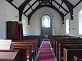
 Inside Holy Trinity, Challacombe (a) - geograph.org.uk - 4501966.jpg 480 × 640; 49 KB
-
 Inside Holy Trinity, Challacombe (b) - geograph.org.uk - 4501968.jpg 480 × 640; 49 KB
-
 Inside Holy Trinity, Challacombe (c) - geograph.org.uk - 4501970.jpg 640 × 480; 32 KB
-
 Inside Holy Trinity, Challacombe (d) - geograph.org.uk - 4501973.jpg 472 × 640; 56 KB
-
 Inside Holy Trinity, Challacombe (e) - geograph.org.uk - 4501976.jpg 480 × 640; 43 KB
-
 Inside Holy Trinity, Challacombe (f) - geograph.org.uk - 4501977.jpg 478 × 640; 39 KB
-
 Inside Holy Trinity, Challacombe (g) - geograph.org.uk - 4501979.jpg 480 × 640; 45 KB
-
 Inside Holy Trinity, Challacombe (h) - geograph.org.uk - 4501982.jpg 480 × 640; 55 KB
-
 Inside Holy Trinity, Challacombe (i) - geograph.org.uk - 4501984.jpg 640 × 480; 59 KB
-
 Isolated beech tree, on the B3358 - geograph.org.uk - 3673721.jpg 1,024 × 768; 165 KB
-
 Junction for Twitchen - geograph.org.uk - 6399520.jpg 1,600 × 1,454; 933 KB
-
 Lane through Challacombe - geograph.org.uk - 5818325.jpg 6,000 × 4,000; 5.74 MB
-
 Lane to Whitefield Barton - geograph.org.uk - 4828880.jpg 1,024 × 768; 252 KB
-
 Lay-by south of Brockenbarrow Farm - geograph.org.uk - 6399502.jpg 1,600 × 1,001; 546 KB
-
 Lee Ball Hill at Leeham Ford Bridge on the river Bray - geograph.org.uk - 3916327.jpg 3,648 × 2,736; 5.08 MB
-
 Lee Ball Hill at Leeham Ford Bridge on the river Bray - geograph.org.uk - 3916331.jpg 3,648 × 2,736; 5.09 MB
-
 Little Swincombe Farmhouse - geograph.org.uk - 4150532.jpg 1,024 × 768; 120 KB
-
 Long Stone at Chapman Barrows, Challacombe Down - geograph.org.uk - 5536884.jpg 1,200 × 900; 379 KB
-
 Long Stone at Chapman Barrows, Challacombe Down - geograph.org.uk - 5536890.jpg 1,200 × 900; 394 KB
-
 Longhorn cattle on Exmoor - geograph.org.uk - 738024.jpg 640 × 480; 64 KB
-
 Longstone Barrow - geograph.org.uk - 4150990.jpg 1,024 × 768; 146 KB
-
 Longstone Barrow - geograph.org.uk - 731641.jpg 640 × 313; 43 KB
-
 Looking across the river Bray just above Bray Reservoir - geograph.org.uk - 3917952.jpg 6,000 × 4,000; 4.13 MB
-

-
 Looking down the river Bray from Challacombe Bridge - geograph.org.uk - 3917909.jpg 3,648 × 2,736; 4.59 MB
-
 Looking down the river Bray from Leeham Ford Bridge - geograph.org.uk - 3916340.jpg 3,648 × 2,736; 4.98 MB
-

-
 Looking east from Chapman Barrows - geograph.org.uk - 4151631.jpg 1,024 × 768; 154 KB
-
 Looking south-southeast down Barton Lane - geograph.org.uk - 4497917.jpg 640 × 480; 100 KB
-
 Looking up the river Bray from a bridge at Challacombe - geograph.org.uk - 3917946.jpg 2,736 × 3,648; 4.5 MB
-
 Looking up the river Bray from Challacombe Bridge - geograph.org.uk - 3917918.jpg 3,648 × 2,736; 4.47 MB
-
 Looking up the river Bray from Leeham Ford Bridge - geograph.org.uk - 3917846.jpg 3,648 × 2,736; 5.16 MB
-
 Looking up the river Bray from Mill Bridge - geograph.org.uk - 3917886.jpg 3,648 × 2,736; 4.47 MB
-
 Memorial, near Chapman Barrows - geograph.org.uk - 4151761.jpg 1,024 × 768; 190 KB
-
 Methodist Chapel, Challacombe - geograph.org.uk - 3673683.jpg 1,024 × 768; 191 KB
-

-
 Mill Bridge - geograph.org.uk - 4828983.jpg 1,024 × 768; 350 KB
-
 Mill Bridge on the river Bray near Challacombe - geograph.org.uk - 3917877.jpg 3,648 × 2,736; 5.02 MB
-
 Mill Bridge on the river Bray near Challacombe Mill - geograph.org.uk - 3917870.jpg 3,587 × 2,690; 5.2 MB
-
 Mill Farm - geograph.org.uk - 4828999.jpg 1,024 × 838; 221 KB
-
 Minor road to Challacombe - geograph.org.uk - 3673350.jpg 1,024 × 768; 182 KB
-
 Moorland path by Chapman Barrows - geograph.org.uk - 5817858.jpg 6,000 × 4,000; 3.96 MB
-
 No littering sign north of Friendship Farm - geograph.org.uk - 5686599.jpg 1,600 × 1,067; 740 KB
-
 North Lane, Challacombe - geograph.org.uk - 3673730.jpg 1,024 × 768; 252 KB
-
 North Lane, east of Challacombe - geograph.org.uk - 6400147.jpg 1,600 × 1,200; 886 KB
-
 North Regis Common - geograph.org.uk - 731682.jpg 640 × 454; 118 KB
-
 North Regis Common prehistoric stone row - geograph.org.uk - 6411170.jpg 1,024 × 607; 252 KB
-
 North Swincombe - geograph.org.uk - 4150542.jpg 1,024 × 768; 164 KB
-
 Old Close Bottom - geograph.org.uk - 3673744.jpg 1,024 × 768; 200 KB
-
 Old Close Bottom near Challacombe, Exmoor - geograph.org.uk - 3424659.jpg 1,600 × 1,151; 323 KB
-
 Open moorland near Long Stone - geograph.org.uk - 5817873.jpg 6,000 × 4,000; 4.59 MB
-
 Ordnance Survey Cut Mark - geograph.org.uk - 4451003.jpg 480 × 640; 134 KB
-
 Outbuildings at Brockenbarrow Farm - geograph.org.uk - 4828444.jpg 1,024 × 768; 236 KB
-
 Outbuildings, Little Swincombe Farm - geograph.org.uk - 4150519.jpg 1,024 × 768; 122 KB
-
 Path above the Bray valley - geograph.org.uk - 5818056.jpg 6,000 × 4,000; 7.38 MB
-
 Path to Chapman Barrows - geograph.org.uk - 4151319.jpg 1,024 × 768; 181 KB
-
 Path to Longstone Barrow - geograph.org.uk - 4151003.jpg 1,024 × 768; 180 KB
-
 Path to Shallowford - geograph.org.uk - 5456198.jpg 5,760 × 3,840; 6.85 MB
-
-
 Pub car park, Challacombe - geograph.org.uk - 4497914.jpg 640 × 480; 65 KB
-
 Radworthy Farm - geograph.org.uk - 731600.jpg 640 × 426; 87 KB
-
 River Bray, Challacombe - geograph.org.uk - 3673654.jpg 1,024 × 768; 205 KB
-
 Road descends to Goat Combe - geograph.org.uk - 3672882.jpg 1,024 × 753; 227 KB
-
 Road junction in Challacombe - geograph.org.uk - 5818331.jpg 6,000 × 4,000; 5.64 MB
-
 Road to Little Rowley - geograph.org.uk - 4828427.jpg 1,024 × 799; 183 KB
-
 Rooksfoot Bridge, Challacombe - geograph.org.uk - 3673387.jpg 1,024 × 768; 277 KB
-
 Rough forest clearing - geograph.org.uk - 6215012.jpg 4,032 × 3,024; 4.92 MB
-
 Rutted field entrance - geograph.org.uk - 5818414.jpg 6,000 × 4,000; 7.47 MB
-
 Saddle Gate - geograph.org.uk - 5033680.jpg 1,024 × 768; 240 KB
-
 Saddle Gate and Saddle Stone - geograph.org.uk - 71328.jpg 640 × 480; 105 KB
-
 Sheep above Twyneford - geograph.org.uk - 738493.jpg 640 × 426; 84 KB
-
 Sheep at Withycombe - geograph.org.uk - 5818391.jpg 6,000 × 4,000; 6.97 MB
-
 Sheep pasture above Swincombe - geograph.org.uk - 4151824.jpg 1,024 × 768; 225 KB
-
 Sheep pasture at Brockenbarrow Farm - geograph.org.uk - 4828724.jpg 1,024 × 768; 255 KB


_-_geograph.org.uk_-_4501871.jpg)
_-_geograph.org.uk_-_4501875.jpg)
_-_geograph.org.uk_-_4501880.jpg)
_-_geograph.org.uk_-_4501882.jpg)
_-_geograph.org.uk_-_4501884.jpg)
_-_geograph.org.uk_-_4501885.jpg)
_-_geograph.org.uk_-_4501890.jpg)
_-_geograph.org.uk_-_4501926.jpg)
_-_geograph.org.uk_-_4501928.jpg)
_-_geograph.org.uk_-_4501929.jpg)
_-_geograph.org.uk_-_4501934.jpg)
_-_geograph.org.uk_-_4501938.jpg)

_-_geograph.org.uk_-_4501942.jpg)
_-_geograph.org.uk_-_4501951.jpg)
_-_geograph.org.uk_-_4501952.jpg)
_-_geograph.org.uk_-_4501955.jpg)
_-_geograph.org.uk_-_4501958.jpg)

_-_geograph.org.uk_-_4501962.jpg)
_-_geograph.org.uk_-_4501964.jpg)


_-_geograph.org.uk_-_4501966.jpg)
_-_geograph.org.uk_-_4501968.jpg)
_-_geograph.org.uk_-_4501970.jpg)
_-_geograph.org.uk_-_4501973.jpg)
_-_geograph.org.uk_-_4501976.jpg)
_-_geograph.org.uk_-_4501977.jpg)
_-_geograph.org.uk_-_4501979.jpg)
_-_geograph.org.uk_-_4501982.jpg)
_-_geograph.org.uk_-_4501984.jpg)


