Category:Castle Cary
Jump to navigation
Jump to search
English: Castle Cary is a town in the South Somerset district of Somerset
town in Somerset, England, UK  Vue de Castle Cary depuis l'ancienne motte castrale. | |||||
| Upload media | |||||
| Instance of | |||||
|---|---|---|---|---|---|
| Location | South Somerset, Somerset, South West England, England | ||||
| Population |
| ||||
| Said to be the same as | Castle Cary (Wikimedia duplicated page, civil parish) | ||||
| official website | |||||
 | |||||
Subcategories
This category has the following 9 subcategories, out of 9 total.
A
C
- Cary Castle (3 F)
- Castle Cary War Memorial (3 F)
G
- The George, Castle Cary (2 F)
M
- Market House, Castle Cary (7 F)
P
- Castle Cary Post Office (2 F)
R
- The Round House, Castle Cary (5 F)
Media in category "Castle Cary"
The following 200 files are in this category, out of 225 total.
(previous page) (next page)-
 A Somerset Hedge - geograph.org.uk - 4612058.jpg 640 × 337; 25 KB
-
 ACF Drill Hall - The Park - geograph.org.uk - 4169211.jpg 1,600 × 1,064; 402 KB
-
 Alford, Dimmer Lane, Frank's House Farm - geograph.org.uk - 6638020.jpg 5,107 × 3,404; 3.67 MB
-
 Alford, Dimmer Lane, Grazing land at Frank's House Farm - geograph.org.uk - 6638023.jpg 6,561 × 4,374; 6.13 MB
-
 Alford, Dimmer Lane, Grazing land at Frank's House Farm - geograph.org.uk - 6638028.jpg 5,677 × 3,785; 5.84 MB
-
 Alford, Dimmer Lane, Park Farm - geograph.org.uk - 6637891.jpg 6,863 × 4,576; 5.62 MB
-
 Alford, Dimmer Lane, Park Farm Dairy - geograph.org.uk - 6638017.jpg 5,910 × 3,940; 4.3 MB
-
 Alford, Farm buildings - geograph.org.uk - 6638005.jpg 7,086 × 4,724; 5.86 MB
-
 Alford, Farm buildings - geograph.org.uk - 6638007.jpg 5,663 × 3,775; 4.34 MB
-
 Alford, Farm buildings at Higher Dimmer Farm - geograph.org.uk - 6638013.jpg 6,375 × 4,251; 5.71 MB
-
 B3153 - geograph.org.uk - 4862474.jpg 640 × 426; 50 KB
-
 B3153 - geograph.org.uk - 5558423.jpg 629 × 640; 100 KB
-
 B3153, a glimpse - geograph.org.uk - 6054881.jpg 1,024 × 681; 262 KB
-
 B3193 near Clanville - geograph.org.uk - 2868775.jpg 640 × 392; 58 KB
-
 Bailey Hill, Castle Cary - geograph.org.uk - 4509560.jpg 792 × 800; 158 KB
-
 Bailey Hill, Castle Cary - geograph.org.uk - 5763609.jpg 2,304 × 1,728; 1.93 MB
-
 Barclays Bank, Castle Cary - geograph.org.uk - 4509612.jpg 787 × 800; 132 KB
-
 Bench Mark, The Market House - geograph.org.uk - 2518619.jpg 480 × 640; 65 KB
-

-
 Bridgewater Buildings, Castle Cary - geograph.org.uk - 4514585.jpg 800 × 751; 146 KB
-

-
 Cary Acupuncture Practice, Castle Cary - geograph.org.uk - 4509551.jpg 800 × 792; 160 KB
-
 Castle Cary Post Office 1988 - Flickr - sludgegulper.jpg 1,504 × 1,019; 137 KB
-
 Castle Cary (9093941198).jpg 3,296 × 2,472; 1.63 MB
-
 Castle Cary - Market Place and George Hotel - geograph.org.uk - 6046890.jpg 1,600 × 1,068; 1.11 MB
-
 Castle Cary Cemetery - geograph.org.uk - 357379.jpg 640 × 480; 97 KB
-
 Castle Cary church.jpg 640 × 477; 79 KB
-
 Castle Cary Constitutional Club - geograph.org.uk - 446576.jpg 640 × 480; 103 KB
-
 Castle Cary fire station.jpg 640 × 426; 169 KB
-
 Castle Cary Horse Pond - geograph.org.uk - 667561.jpg 480 × 640; 60 KB
-
 Castle Cary Library - geograph.org.uk - 470373.jpg 480 × 640; 94 KB
-
 Castle Cary methodist chapel - geograph.org.uk - 460379.jpg 477 × 640; 77 KB
-
 Castle Cary Methodist Church - geograph.org.uk - 5763610.jpg 2,304 × 1,728; 838 KB
-
 Castle Cary Post Office - geograph.org.uk - 4509570.jpg 800 × 692; 209 KB
-
 Castle Cary Public Library - geograph.org.uk - 4509662.jpg 800 × 787; 174 KB
-
 Castle Cary Sports Pavilion - geograph.org.uk - 4509820.jpg 800 × 576; 97 KB
-
 Castle Cary ^ District Museum, High Street - geograph.org.uk - 4934962.jpg 3,264 × 2,448; 1.92 MB
-
 Castle Cary, The George Hotel - geograph.org.uk - 5793414.jpg 1,600 × 1,103; 637 KB
-
 Castle Cary, White, Ironmonger - geograph.org.uk - 5793420.jpg 1,600 × 1,089; 715 KB
-
 Catherines Close bungalows, Castle Cary - geograph.org.uk - 4509749.jpg 800 × 535; 168 KB
-

-
 Cattle grazing, Clanville Manor - geograph.org.uk - 4862472.jpg 640 × 426; 63 KB
-
 Church Street, Castle Cary - geograph.org.uk - 5768917.jpg 2,204 × 1,588; 1.77 MB
-
 Clanville Manor Farm - geograph.org.uk - 5558415.jpg 640 × 426; 59 KB
-
 Conveniently here - geograph.org.uk - 3873829.jpg 2,304 × 1,704; 1.63 MB
-

-
 Coombe Close corner house, Castle Cary - geograph.org.uk - 4509835.jpg 800 × 605; 152 KB
-
 Coombe Close, Castle Cary - geograph.org.uk - 4509827.jpg 800 × 688; 138 KB
-
 Countryside near Clanville - geograph.org.uk - 4612042.jpg 640 × 426; 39 KB
-
 Countryside near North Barrow - geograph.org.uk - 4612062.jpg 640 × 426; 40 KB
-

-
 Dimmer Farm - geograph.org.uk - 4612048.jpg 640 × 426; 33 KB
-
 Dimmer Hill - geograph.org.uk - 4612045.jpg 640 × 426; 35 KB
-
-
 Direction Sign - Signpost on the A371 in Castle Cary - geograph.org.uk - 6055867.jpg 1,117 × 1,663; 458 KB
-
 Direction Sign - Signpost on the B3153 in Clanville - geograph.org.uk - 6083810.jpg 1,561 × 1,057; 438 KB
-

-
 Dog tie - geograph.org.uk - 3873816.jpg 1,704 × 2,304; 1.54 MB
-
 Donnes Terrace, Castle Cary - geograph.org.uk - 4514557.jpg 800 × 503; 99 KB
-
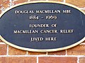 Douglas Macmillan plaque - geograph.org.uk - 460372.jpg 640 × 477; 82 KB
-
 Douglas Macmillan's house - geograph.org.uk - 460376.jpg 640 × 477; 95 KB
-
 Eastern end of Torbay Road, Castle Cary - geograph.org.uk - 4514549.jpg 583 × 640; 101 KB
-
 Electricity sub station - geograph.org.uk - 467988.jpg 640 × 477; 76 KB
-
 Factory on Torbay Road Industrial Estate - geograph.org.uk - 5822506.jpg 1,024 × 681; 48 KB
-
 Farm buildings - geograph.org.uk - 4612056.jpg 640 × 426; 37 KB
-
 Farmland at Clanville Manor - geograph.org.uk - 2521282.jpg 640 × 433; 158 KB
-
 Farmland by Dimmer Lane - geograph.org.uk - 2868786.jpg 640 × 426; 56 KB
-
 Farmland, Blackworthy Hill - geograph.org.uk - 5114317.jpg 640 × 426; 43 KB
-
 Fire Station, Castle Cary - geograph.org.uk - 666906.jpg 640 × 480; 59 KB
-
 Five trees along a B road - geograph.org.uk - 5909115.jpg 1,024 × 681; 136 KB
-
 Footpath, south-west of Castle Cary - geograph.org.uk - 732453.jpg 640 × 480; 159 KB
-
 Fore Street, Castle Cary - geograph.org.uk - 5768952.jpg 2,218 × 1,606; 1.62 MB
-
-

-
 Former Two Swans pub in Castle Cary - geograph.org.uk - 4509449.jpg 800 × 594; 143 KB
-

-
 Galhampton, Field with broken gate access - geograph.org.uk - 6637878.jpg 4,547 × 3,031; 3.69 MB
-
 Going shopping in Castle Cary - geograph.org.uk - 990466.jpg 640 × 480; 96 KB
-
 Golden Plaice, Castle Cary - geograph.org.uk - 4509443.jpg 779 × 800; 184 KB
-
-

-
 Heal and Sole Holistics in Castle Cary - geograph.org.uk - 4509456.jpg 800 × 629; 142 KB
-
 Hedge end - geograph.org.uk - 5114319.jpg 640 × 426; 46 KB
-
 Hedge near Dimmer Farm - geograph.org.uk - 4612052.jpg 640 × 426; 34 KB
-
 Hedge, Brookfield Farm - geograph.org.uk - 4612055.jpg 640 × 426; 40 KB
-
 High Street, Castle Cary - geograph.org.uk - 5373287.jpg 640 × 427; 77 KB
-
 High Street, Castle Cary - geograph.org.uk - 5785872.jpg 2,214 × 1,600; 2.07 MB
-
 Hillside above Castle Cary - geograph.org.uk - 5373282.jpg 640 × 427; 70 KB
-
 Horse Pond Inn, Castle Cary - geograph.org.uk - 667533.jpg 640 × 492; 76 KB
-
 House near Clanville - geograph.org.uk - 4768919.jpg 1,920 × 1,189; 594 KB
-
 Houses above Ansford Road, Castle Cary - geograph.org.uk - 4509823.jpg 800 × 522; 116 KB
-

-
 Houses in North Street, Castle Cary - geograph.org.uk - 5373291.jpg 640 × 427; 95 KB
-
 Houses on South Street, Castle Cary - geograph.org.uk - 5768807.jpg 2,304 × 1,728; 862 KB
-
-
 Industrial Estate - geograph.org.uk - 5391923.jpg 640 × 426; 28 KB
-

-
 Kingsacre Castle Cary - geograph.org.uk - 4509523.jpg 800 × 717; 171 KB
-
 Leaving Castle Cary on the B3152 - geograph.org.uk - 4929608.jpg 2,592 × 1,944; 1.14 MB
-
 Library, Castle Cary - geograph.org.uk - 667614.jpg 640 × 480; 100 KB
-
 Line of trees - geograph.org.uk - 5391927.jpg 640 × 426; 45 KB
-
 Lodge Hill, Castle Cary - geograph.org.uk - 3903379.jpg 3,776 × 2,520; 3.98 MB
-

-
 Looking north-northeast along Church Street - geograph.org.uk - 4934920.jpg 3,264 × 2,448; 1.64 MB
-
 Looking north-northeast up the High Street - geograph.org.uk - 4934893.jpg 3,264 × 2,410; 2.03 MB
-
 Looking southwest down the High Street - geograph.org.uk - 4934943.jpg 3,264 × 2,448; 2.04 MB
-
 Looking to Clanville Manor Farm - geograph.org.uk - 5188649.jpg 640 × 426; 46 KB
-
 Looking west along Upper High Street - geograph.org.uk - 4934932.jpg 3,264 × 2,448; 1.96 MB
-

-
 Lower Woodcock Street, Castle Cary - geograph.org.uk - 4509438.jpg 800 × 696; 128 KB
-
 Market House - geograph.org.uk - 4191832.jpg 501 × 640; 396 KB
-
 Market House - geograph.org.uk - 6402248.jpg 1,024 × 768; 175 KB
-

-
-
 New Houses near Cary Hill - geograph.org.uk - 6026314.jpg 640 × 412; 175 KB
-
 North Barrow, Cockhill Bridge - geograph.org.uk - 6637999.jpg 7,383 × 4,922; 7.1 MB
-
 North Barrow, Field with gated entrance - geograph.org.uk - 6637884.jpg 6,617 × 4,411; 6.87 MB
-
 North Barrow, Maize crop - geograph.org.uk - 6637879.jpg 6,696 × 4,464; 6.98 MB
-
 North Barrow, Railway bridge identification number - geograph.org.uk - 6637887.jpg 6,208 × 4,139; 7.29 MB
-

-
 Not in Pudding Lane - geograph.org.uk - 3873774.jpg 2,304 × 1,704; 1.31 MB
-
-
 Observation point, Lodge Hill, Castle Cary - geograph.org.uk - 3903370.jpg 3,776 × 2,520; 4.05 MB
-
 Oilseed rape - geograph.org.uk - 5558413.jpg 640 × 426; 86 KB
-
-

-

-
 Old Milestone, B3152, Fore Street, Castle Cary (geograph 6072058).jpg 958 × 1,704; 342 KB
-
 Old signs in Woodcock Street - geograph.org.uk - 3873833.jpg 1,704 × 2,304; 1.54 MB
-
 Old Toll House, Galhampton - geograph.org.uk - 6115004.jpg 640 × 486; 136 KB
-
 Old-style signpost in Castle Cary - geograph.org.uk - 4514545.jpg 800 × 670; 151 KB
-
 Ordnance Survey Cut Mark - geograph.org.uk - 3929120.jpg 4,000 × 3,000; 4.59 MB
-
 Ordnance Survey Cut Mark - geograph.org.uk - 4261360.jpg 640 × 480; 97 KB
-
 Ordnance Survey Cut Mark - geograph.org.uk - 4261361.jpg 480 × 640; 80 KB
-
 Ordnance Survey Cut Mark - geograph.org.uk - 4261362.jpg 480 × 640; 126 KB
-
 Paddock Drain - geograph.org.uk - 3873781.jpg 1,704 × 2,304; 1.48 MB
-
 Passenger Train at Cockhill - geograph.org.uk - 3831644.jpg 1,200 × 811; 1.27 MB
-
 Phillips Tyres - geograph.org.uk - 4182438.jpg 640 × 426; 59 KB
-
 Pither's Yard, Castle Cary - geograph.org.uk - 4774478.jpg 2,125 × 3,117; 2.77 MB
-
 Pithers Yard - geograph.org.uk - 3873808.jpg 2,304 × 1,704; 1.76 MB
-
 Pond and war memorial, Castle Cary - geograph.org.uk - 5373284.jpg 640 × 427; 89 KB
-

-
 Priory Close, Castle Cary - geograph.org.uk - 4509530.jpg 800 × 611; 117 KB
-
 Public conveniences, Castle Cary - geograph.org.uk - 3903393.jpg 3,776 × 2,520; 4.09 MB
-
 Railway towards Yeovil, near Cockhill - geograph.org.uk - 730363.jpg 640 × 480; 130 KB
-
 Rape field near Castle Cary - geograph.org.uk - 103560.jpg 640 × 427; 113 KB
-
 Redlands Farm, Galhampton - geograph.org.uk - 5768176.jpg 2,238 × 1,636; 1.98 MB
-
 Road from Castle Cary to North Barrow - geograph.org.uk - 730000.jpg 640 × 480; 125 KB
-
 Road junction of A359 with B3152 at Redlands Farm - geograph.org.uk - 6224465.jpg 1,600 × 1,202; 706 KB
-

-
 Shopfront in Fore Street, Castle Cary - geograph.org.uk - 375887.jpg 640 × 480; 122 KB
-

-
 Sign for the White Hart, Castle Cary - geograph.org.uk - 667571.jpg 511 × 640; 62 KB
-
 Somerset farmland - geograph.org.uk - 4612066.jpg 640 × 426; 47 KB
-
 Something in the electricity sub station - geograph.org.uk - 467989.jpg 640 × 477; 141 KB
-
-
 Sportsman's Lodge Farm - geograph.org.uk - 4929620.jpg 2,592 × 1,944; 987 KB
-
 St John's Priory, Castle Cary - geograph.org.uk - 1803994.jpg 444 × 640; 148 KB
-
 Station Road houses in Castle Cary - geograph.org.uk - 4509493.jpg 800 × 707; 132 KB
-

-
 Station Road, Castle Cary - geograph.org.uk - 5373278.jpg 640 × 427; 66 KB
-
 Stone house in Castle Cary - geograph.org.uk - 460381.jpg 640 × 477; 123 KB
-
 Street scene, Castle Cary - geograph.org.uk - 2524701.jpg 640 × 480; 84 KB
-
 Street Scene, Castle Cary - geograph.org.uk - 667628.jpg 640 × 492; 81 KB
-
 Sutton Dene, Castle Cary - geograph.org.uk - 4514552.jpg 800 × 677; 153 KB
-

-

-

-

-
 Telephone box, Castle Cary - geograph.org.uk - 2518618.jpg 480 × 640; 83 KB
-
 The Clock Shop, Castle Cary - geograph.org.uk - 4509677.jpg 800 × 795; 158 KB
-
 The Horse Pond - geograph.org.uk - 4182423.jpg 1,600 × 1,064; 491 KB
-
 The Market House, Castle Cary - geograph.org.uk - 2524681.jpg 480 × 640; 71 KB
-
 The Market House, Castle Cary - geograph.org.uk - 4515719.jpg 3,504 × 2,336; 3.43 MB
-
 The moat garden - geograph.org.uk - 4605123.jpg 640 × 480; 101 KB
-
 The Pat Jones Gate - geograph.org.uk - 3903091.jpg 3,776 × 2,520; 4.36 MB
-
 The Pitching, Castle Cary - geograph.org.uk - 4509581.jpg 800 × 792; 188 KB
-
 The Return, Castle Cary - geograph.org.uk - 667551.jpg 640 × 480; 138 KB
-
 The Round House - geograph.org.uk - 4934881.jpg 3,264 × 2,448; 2.15 MB
-
 The round House in Bailey Hill, Castle Cary - geograph.org.uk - 5071095.jpg 1,600 × 1,200; 498 KB
-
 The Triangle, Castle Cary - geograph.org.uk - 5768940.jpg 2,304 × 1,728; 1.54 MB
-
 The Triangle, Castle Cary - geograph.org.uk - 5768942.jpg 2,304 × 1,728; 1.45 MB
-
 The White Hart, Castle Cary - geograph.org.uk - 667569.jpg 640 × 498; 80 KB
-
 The Wine Wizzard in Castle Cary - geograph.org.uk - 4509557.jpg 800 × 785; 148 KB
-

-
 Tollhouse near Galhampton - geograph.org.uk - 1992106.jpg 640 × 480; 66 KB
-
 Top of Ansford Hill, Higher Ansford - geograph.org.uk - 4509971.jpg 800 × 566; 143 KB
-
 Tree in field - geograph.org.uk - 6446631.jpg 1,024 × 681; 166 KB
-
 Trees by B road - geograph.org.uk - 5510125.jpg 640 × 426; 39 KB
-
 Tudor style rooftops in Castle Cary - geograph.org.uk - 460367.jpg 640 × 477; 61 KB
-
 Upper High Street, Castle Cary - geograph.org.uk - 5785866.jpg 2,304 × 1,728; 847 KB
-
 Van on B road - geograph.org.uk - 5668278.jpg 640 × 426; 59 KB
-
-
 Venus Cottage, Castle Cary - geograph.org.uk - 4509848.jpg 800 × 555; 164 KB
-
 Victoria Court, Castle Cary - geograph.org.uk - 4509532.jpg 800 × 736; 196 KB
-
 Victoria Park, Castle Cary - geograph.org.uk - 4514541.jpg 800 × 508; 93 KB
-
 View to Clanville Manor - geograph.org.uk - 5909110.jpg 1,024 × 681; 70 KB
-
 View to Clanville Manor Farm - geograph.org.uk - 5668279.jpg 640 × 426; 54 KB
-
 View to Clanville Manor Farm - geograph.org.uk - 5696518.jpg 640 × 426; 71 KB
-
 View towards Castle Cary - geograph.org.uk - 108252.jpg 640 × 380; 160 KB


.jpg)


.jpg)


.jpg)
.jpg)
.jpg)
.jpg)


