Category:Castiel
Jump to navigation
Jump to search
| Object location | | View all coordinates using: OpenStreetMap |
|---|
former municipality of Switzerland in Graubünden   | |||||
| Upload media | |||||
| Pronunciation audio | |||||
|---|---|---|---|---|---|
| Instance of | |||||
| Location |
| ||||
| Area |
| ||||
| Elevation above sea level |
| ||||
| Replaced by |
| ||||
| official website | |||||
 | |||||
Subcategories
This category has the following 6 subcategories, out of 6 total.
A
- Alte Brücke Castielertobel (4 F)
C
- Castielertobel-Viaduct (18 F)
L
- Lafet (2 F)
- Lüen-Castiel railway station (8 F)
R
- Reformierte Kirche Castiel (7 F)
Media in category "Castiel"
The following 20 files are in this category, out of 20 total.
-
 Abbruch Castielertobel.jpg 2,048 × 1,536; 1.16 MB
-
 Calfreisen-Schanfigg-01.jpg 1,854 × 500; 1.03 MB
-
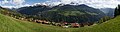
 Castiel 2020.jpeg 4,032 × 3,024; 3.53 MB
-
 Castiel 2020.jpg 5,472 × 3,648; 10.41 MB
-
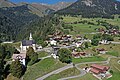
 Castiel Ansicht.jpg 3,379 × 2,569; 1.46 MB
-
 Castiel Dorf.jpg 2,048 × 1,536; 1.33 MB
-
 Castiel Haus Podesta.jpeg 3,446 × 2,683; 2.22 MB
-
 Castiel wappen.svg 438 × 480; 25 KB
-
 Castiel.jpg 2,524 × 1,804; 1.2 MB
-
 Castielertobel.jpg 2,048 × 1,536; 4.58 MB
-
 Castielertobelstrasse2.jpg 2,048 × 1,536; 4.31 MB
-
 Castielertobelstrasse3.jpg 2,048 × 1,536; 4.45 MB
-
 Castielertobelstrasse5.jpg 2,048 × 1,536; 3.41 MB
-
 Karte Gemeinde Castiel 2007.png 1,181 × 968; 265 KB
-
 Karte Gemeinde Castiel 2008.png 1,181 × 968; 264 KB
-
 Karte Gemeinde Castiel 2009.png 1,476 × 1,211; 454 KB
-
 Karte Gemeinde Castiel 2010.png 1,476 × 1,211; 444 KB
-
 Karte Gemeinde Castiel.png 1,181 × 933; 228 KB
-
Roh-Castiel.ogg 1.6 s; 32 KB
-
 Schild Bärenfalle Tunnel.jpg 2,048 × 1,536; 1.3 MB


