Category:Castell de Sant Agustí
Jump to navigation
Jump to search
| Object location | | View all coordinates using: OpenStreetMap |
|---|
 | |||||
| Upload media | |||||
| Instance of | |||||
|---|---|---|---|---|---|
| Location | Abella de la Conca, Pallars Jussà, Province of Lleida, Catalonia | ||||
| Heritage designation | |||||
| Elevation above sea level |
| ||||
 | |||||
Català: Castell de Sant Agustí (Abella de la Conca)
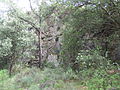
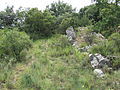
This is a category about an archaeological zone listed in the Catalan heritage register of Béns Culturals d'Interès Nacional and the Spanish heritage register of Bienes de Interés Cultural under the reference IPAPC-8876. |
Media in category "Castell de Sant Agustí"
The following 3 files are in this category, out of 3 total.
-
 Abella de la Conca. Castell de Sant Agustí 1.JPG 2,592 × 1,944; 1.27 MB
-
 Abella de la Conca. Castell de Sant Agustí 2.JPG 2,592 × 1,944; 1.27 MB
-
 Abella de la Conca. Castell de Sant Agustí 3.JPG 2,592 × 1,944; 1.26 MB

