Category:Castell de Querroig
Jump to navigation
Jump to search
| Object location | | View all coordinates using: OpenStreetMap |
|---|
|
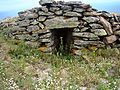
This building is inscrit au titre des monuments historiques de la France. It is indexed in the base Mérimée, a database of architectural heritage maintained by the French Ministry of Culture, under the reference PA66000051
|
 | |||||
| Upload media | |||||
| Instance of |
| ||||
|---|---|---|---|---|---|
| Part of | |||||
| Location |
| ||||
| Architectural style | |||||
| Heritage designation | |||||
| Elevation above sea level |
| ||||
 | |||||
Català: Castell de Querroig a Portbou
This is a category about a building listed in the Catalan heritage register as Bé Cultural d'Interès Local (BCIL) under the reference IPA-30602. |
Media in category "Castell de Querroig"
The following 13 files are in this category, out of 13 total.
-
 Castell de Querroig (rètol).JPG 2,592 × 1,944; 2.73 MB
-
 Castell de Querroig - 1.jpg 2,592 × 3,456; 9.52 MB
-
 Castell de Querroig - 2.jpg 3,456 × 2,592; 8.43 MB
-
 Castell de Querroig - 3.jpg 3,456 × 2,592; 8.82 MB
-
 Castell de Querroig - 4.jpg 3,456 × 2,592; 9.49 MB
-
 Castell de Querroig - 5.jpg 3,456 × 2,592; 11.05 MB
-
 Castell de Querroig - 6.jpg 2,592 × 3,456; 8.71 MB
-
 Castell de Querroig - torre.JPG 2,592 × 1,944; 2.93 MB
-
 Puig del Querroig.JPG 2,592 × 1,944; 2.95 MB
-
 Ruïnes castell de Querroig -1.JPG 2,592 × 1,944; 2.76 MB
-
 Ruïnes castell de Querroig -2.JPG 2,592 × 1,944; 2.62 MB
-
 Ruïnes castell de Querroig -3.JPG 2,592 × 1,944; 3 MB
-
 Torre castell de Querroig.JPG 2,592 × 1,944; 2.95 MB
.JPG)


