Category:Castell de Montornès
Jump to navigation
Jump to search
| Object location | | View all coordinates using: OpenStreetMap |
|---|
Spanish fort  | |||||
| Upload media | |||||
| Instance of | |||||
|---|---|---|---|---|---|
| Location | |||||
| Heritage designation | |||||
 | |||||
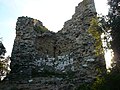
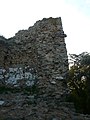
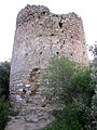
Català: Castell de Montornès, obra romànica del segle XI entre els municipis de Montornès del Vallès i Vallromanes (Vallès Oriental).
This is a category about a monument listed in the Catalan heritage register of Béns Culturals d'Interès Nacional and the Spanish heritage register of Bienes de Interés Cultural under the reference RI-51-0005556. |
Media in category "Castell de Montornès"
The following 18 files are in this category, out of 18 total.
-
 Capella de Sant Miquel de Montornès.jpg 1,024 × 683; 346 KB
-
 Castell de Montornès - amb turó.jpg 3,072 × 2,304; 1.27 MB
-
 Castell de Montornès - P1070594.jpg 4,320 × 3,240; 5.17 MB
-
 Castell de Montornès - restes d'una torre.jpg 3,072 × 2,304; 1.77 MB
-
 Castell de Montornès - restes.jpg 2,304 × 3,072; 2.15 MB
-
 Castell de Montornès P1180341.JPG 3,072 × 2,304; 3.27 MB
-
 Castell de Montornès P1180342.JPG 3,072 × 2,304; 3.29 MB
-
 Castell de Montornès P1180343.JPG 3,072 × 2,304; 3.32 MB
-
 Castell de Montornès P1180345.JPG 3,072 × 2,304; 3.22 MB
-
 Castell de Montornès P1180348.JPG 3,072 × 2,304; 3.17 MB
-
 Castell de Montornès P1180349.JPG 2,304 × 3,072; 3.28 MB
-
 Castell de Montornès P1180350.JPG 3,072 × 2,304; 3.45 MB
-
 Castell de Montornès P1180371.JPG 3,072 × 2,304; 3.33 MB
-
 Castell de Montornès P1180372.JPG 3,072 × 2,304; 3.3 MB
-
 Castell de Montornès P1180373.JPG 3,072 × 2,304; 3.34 MB
-
 Castell de Sant Miquel - Montornès del Vallès - P1100443.jpg 4,320 × 3,240; 5.36 MB
-
 Castell de Sant Miquel - Montornès del Vallès - P1100444.jpg 4,320 × 3,240; 5.25 MB
-
 Castell Montornes IMG 3658.JPG 480 × 640; 117 KB


