Category:Castell de Ferran (Passanant i Belltall)
Jump to navigation
Jump to search
| Object location | | View all coordinates using: OpenStreetMap |
|---|
_-_1.jpg) | |||||
| Upload media | |||||
| Instance of | |||||
|---|---|---|---|---|---|
| Location | Passanant i Belltall, Conca de Barberà, Camp de Tarragona, Tarragona Province, Catalonia | ||||
| Heritage designation |
| ||||
| Elevation above sea level |
| ||||
 | |||||
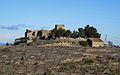
Català: Castell de Ferran. C. de la Pobla, 2, la Pobla de Ferran (Passanant i Belltall)
This is a category about a building listed in the Catalan heritage register as Bé Cultural d'Interès Local (BCIL) under the reference IPA-1351. |
Media in category "Castell de Ferran (Passanant i Belltall)"
The following 8 files are in this category, out of 8 total.
-
 Castell de Ferran (Passanant i Belltall) - 1.jpg 800 × 510; 236 KB
-
 Castell de Ferran (Passanant i Belltall) - 2.jpg 800 × 499; 205 KB
-
 Castell de Ferran (Passanant i Belltall) - 3.jpg 4,608 × 3,072; 5.67 MB
-
 Castell de la Pobla de Ferran (març 2011) - panoramio.jpg 1,536 × 2,048; 1.18 MB
-
 Castell de la Pobla de Ferran - panoramio.jpg 1,200 × 900; 518 KB
-
 Ferran IMG 3642 01.jpg 675 × 900; 210 KB
-
 Ferran IMG 3642 02.jpg 675 × 900; 210 KB
-
 La Pobla de Ferran (Passanant i Belltall).jpg 800 × 600; 161 KB
_-_2.jpg)
_-_3.jpg)
_-_panoramio.jpg)


.jpg)