Category:Castell de Clariana (Argençola)
Jump to navigation
Jump to search
| Object location | | View all coordinates using: OpenStreetMap |
|---|
cultural property in Argençola, Spain _2.jpg) | |||||
| Upload media | |||||
| Instance of | |||||
|---|---|---|---|---|---|
| Location | Argençola, Anoia, Barcelona Province, Catalonia | ||||
| Street address |
| ||||
| Heritage designation | |||||
 | |||||
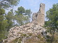
Català: Castell de Clariana, obra medieval del segle XII al municipi d'Argençola (Anoia)
This is a category about a monument listed in the Catalan heritage register of Béns Culturals d'Interès Nacional and the Spanish heritage register of Bienes de Interés Cultural under the reference RI-51-0005179. |
Media in category "Castell de Clariana (Argençola)"
The following 2 files are in this category, out of 2 total.
-
 Castell de Clariana (Argençola) 1.jpg 2,048 × 1,536; 1.47 MB
-
 Castell de Clariana (Argençola) 2.jpg 2,048 × 1,536; 1.29 MB
_1.jpg)