Category:Carrigaholt
Jump to navigation
Jump to search

town in Munster, Ireland  | |||||
| Upload media | |||||
| Instance of | |||||
|---|---|---|---|---|---|
| Location | County Clare, Munster, Ireland | ||||
 | |||||
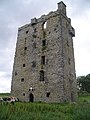
English: Carrigaholt is a small fishing village in County Clare, Ireland. It lies at the mouth of the Moyarta river, which flows into the estuary of the River Shannon about 15km from the tip of the Loop Head peninsula and about 10km from the resort town of Kilkee on the north coast of the peninsula. The village boasts a ruined castle that stood guard over the mouth of the Shannon and the local fishing pier. Fishing is still continued in the village with a small number of boats delivering their catches to a local processing company. The village is also the local centre for the local farming community. The village has benefited recently from tourism, mainly provided by residents from Limerick some 110km to the east. The village has two restaurants, a fast food take-away and four public houses, some of which offer live entertainment, particularly during the summer high season. There is a holiday caravan park located nearby. A local company (Dolphinwatch) offers boating trips to observe dolphins in the mouth of the Shannon River, home to one of the largest pods in Europe. The Carrigaholt Sea Angling Centre (FishandStay) offers fishing packages for up to 8 fisherman at a time and runs a purpose built Lochin 366. Catches include Ray, Conger, Bass, Dogfish, Tope, Cod, Pollock, Hake and Turbot. Other features include a beach suitable for swimming and watersports, two piers and local village shopping for food necessities.
Gaeilge: Sráidbhaile in Éirinn is ea Carraig an Chabhaltaigh. Tá an baile suite i g Contae an Chláir.
Media in category "Carrigaholt"
The following 45 files are in this category, out of 45 total.
-
 A sleepy afternoon in Carrigaholt - geograph.org.uk - 4682462.jpg 4,320 × 3,240; 2.09 MB
-
 Admiralty Chart No 1547 Shannon Carrigaholt to Scattery, Published 1843.jpg 19,493 × 11,245; 18.34 MB
-
 Carrigaholt - geograph.org.uk - 55299.jpg 640 × 419; 86 KB
-
 Carrigaholt 25-09-1993 - panoramio - Bas van Oorschot.jpg 850 × 541; 69 KB
-
 Carrigaholt 25-09-1993 - panoramio.jpg 850 × 569; 117 KB
-
 Carrigaholt Castle - geograph.org.uk - 2171383.jpg 640 × 427; 205 KB
-
 Carrigaholt Castle - geograph.org.uk - 4682477.jpg 2,878 × 2,160; 1.5 MB
-
 Carrigaholt graveyard - geograph.org.uk - 1883204.jpg 640 × 427; 188 KB
-
 Carrigaholt New Quay - geograph.org.uk - 1883200.jpg 640 × 427; 178 KB
-
 Carrigaholt Old Quay.jpg 1,632 × 1,224; 481 KB
-
 Carrigaholt Post Office.jpg 4,032 × 3,024; 2.62 MB
-
 Carrigaholt Quay - geograph.org.uk - 2171390.jpg 640 × 428; 233 KB
-
 Carrigaholt Quay - geograph.org.uk - 2171399.jpg 640 × 426; 162 KB
-

-

-

-

-

-

-

-

-

-

-

-

-

-
 Loop Head Peninsula - Carrigaholt - The Long Dock Pub - geograph.org.uk - 3121087.jpg 2,288 × 1,525; 2.76 MB
-

-

-

-

-

-

-

-

-

-
 O’ Curry College, better known as Coláiste Uí Chomhraidhe close up.jpg 5,152 × 3,864; 5.06 MB
-
 O’ Curry College, better known as Coláiste Uí Chomhraidhe, Carrigaholt.jpg 5,152 × 3,864; 5.5 MB
-
 Plaque O’ Curry College, better known as Coláiste Uí Chomhraidhe, Carrigaholt.jpg 5,152 × 3,864; 5.26 MB
-
 Pub & shop Carrigaholt.jpg 1,632 × 1,224; 362 KB
-
 Ruin of Kilcrony Church, slit window.jpg 3,864 × 5,152; 6.48 MB
-
 The Long Dock, Carrigaholt.jpg 5,152 × 3,461; 2.09 MB
-
 The Swiss In Carrigaholt.JPG 3,664 × 2,748; 2.56 MB
-
 Wreck of the "Okeanos" - geograph.org.uk - 14196.jpg 640 × 480; 94 KB
-
 Carrigaholt Castle - geograph.org.uk - 12778.jpg 480 × 640; 162 KB


_Bridge,_Moyarta_River,_Harbour_-_geograph.org.uk_-_3122910.jpg)


_-_geograph.org.uk_-_3122896.jpg)
_-_geograph.org.uk_-_3122897.jpg)


_-_geograph.org.uk_-_3122891.jpg)


