Category:Cardington, Bedfordshire
Jump to navigation
Jump to search
village and civil parish in the Borough of Bedford in Bedfordshire, England  | |||||
| Upload media | |||||
| Instance of | |||||
|---|---|---|---|---|---|
| Location | Bedford, Bedfordshire, East of England, England | ||||
| Population |
| ||||
 | |||||
Subcategories
This category has the following 7 subcategories, out of 7 total.
C
K
- The Kings Arms, Cardington (2 F)
M
R
- Cardington railway station (1 F)
V
- Cardington Village Sign (2 F)
W
Pages in category "Cardington, Bedfordshire"
This category contains only the following page.
Media in category "Cardington, Bedfordshire"
The following 73 files are in this category, out of 73 total.
-

-
 A421 eastbound - geograph.org.uk - 4873429.jpg 640 × 480; 32 KB
-
 A421 northbound, turning for A603 - geograph.org.uk - 4431373.jpg 640 × 480; 44 KB
-
 A421, eastbound - geograph.org.uk - 5005188.jpg 640 × 426; 52 KB
-
 A421, eastbound - geograph.org.uk - 5005192.jpg 640 × 426; 47 KB
-
 Across the wheat field to the Cardington sheds - geograph.org.uk - 5458176.jpg 3,648 × 2,736; 2.66 MB
-
 Airlander, moored - geograph.org.uk - 5458166.jpg 3,648 × 2,736; 2.77 MB
-
 Approach to Chapel End, Cardington, Beds - geograph.org.uk - 386609.jpg 640 × 480; 253 KB
-
 Barn renovation at Hillfoot Farm - geograph.org.uk - 427954.jpg 620 × 470; 118 KB
-
 Beans near Cardington - geograph.org.uk - 1834223.jpg 1,024 × 768; 200 KB
-

-

-
 Bridleway by the field drain - geograph.org.uk - 4191204.jpg 1,600 × 1,067; 494 KB
-
 Bridleway goes through the hedge - geograph.org.uk - 4191209.jpg 1,600 × 1,067; 786 KB
-
 Bridleway to Cotton End - geograph.org.uk - 4191229.jpg 1,200 × 1,600; 622 KB
-
 Cardington Hangars and the latest airship - geograph.org.uk - 5096157.jpg 1,600 × 1,066; 416 KB
-
 Cardington lock on the Great Ouse 2005 - geograph.org.uk - 5229970.jpg 1,200 × 1,600; 651 KB
-
 Church Lane, Cardington - geograph.org.uk - 724874.jpg 640 × 426; 100 KB
-
 Cople Road, Cardington - geograph.org.uk - 6627055.jpg 1,892 × 1,236; 1.22 MB
-
 Cople Road, Cardington, Beds - geograph.org.uk - 386625.jpg 640 × 480; 87 KB
-
 Cople Road, heading east to Cople - geograph.org.uk - 3631816.jpg 1,024 × 768; 234 KB
-
 Cottage Farm Nurseries Cople Road, Cardington - geograph.org.uk - 5617105.jpg 4,896 × 3,672; 6.42 MB
-
 Crashed Airship near Cardington sheds - geograph.org.uk - 5617106.jpg 4,896 × 3,672; 6.31 MB
-
 Disused railway embankment - geograph.org.uk - 427976.jpg 640 × 480; 95 KB
-

-
 Farm machinery in front of Pasture Farm - geograph.org.uk - 4191217.jpg 1,600 × 1,067; 611 KB
-
 Farm track under the disused railway embankment - geograph.org.uk - 4191256.jpg 1,600 × 1,067; 576 KB
-
 Farmland east of Chapel End - geograph.org.uk - 3633106.jpg 1,024 × 768; 135 KB
-
 Farmland west of Cople - geograph.org.uk - 3633114.jpg 1,024 × 768; 162 KB
-
 Field and hedge north of Manor Farm - geograph.org.uk - 799353.jpg 640 × 359; 87 KB
-
 Field by Southill Road, Warden Street - geograph.org.uk - 6629578.jpg 1,920 × 1,280; 1.38 MB
-
 Field by Wood End Farm with copse beyond - geograph.org.uk - 4191261.jpg 1,600 × 1,067; 517 KB
-
 Field entrance, north side of Cople Road - geograph.org.uk - 3631828.jpg 1,024 × 768; 119 KB
-
 Field with reservoir beyond - geograph.org.uk - 4191259.jpg 1,600 × 1,067; 442 KB
-
 Fields west of Southill Road - geograph.org.uk - 3350411.jpg 640 × 475; 57 KB
-
 Footpath to Southill Road - geograph.org.uk - 4191220.jpg 1,200 × 1,600; 573 KB
-
 Footpath to Water End - geograph.org.uk - 3683040.jpg 1,600 × 1,067; 444 KB
-
 Freshly tilled field with a view of the sheds - geograph.org.uk - 3683037.jpg 1,600 × 1,072; 391 KB
-
 Games on the green - geograph.org.uk - 3683003.jpg 1,600 × 1,068; 503 KB
-
 Gas pipeline marker, Cople Road - geograph.org.uk - 3633099.jpg 1,024 × 768; 172 KB
-
 Granary, Home Farm, Cardington - geograph.org.uk - 5948375.jpg 1,200 × 1,600; 288 KB
-
 Hill near Warden Street - geograph.org.uk - 4506209.jpg 4,320 × 3,240; 4.38 MB
-
 Howard Close - geograph.org.uk - 3703265.jpg 640 × 480; 54 KB
-
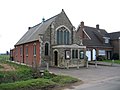
 Howard Memorial Church, Cardington - geograph.org.uk - 6627060.jpg 1,920 × 1,280; 974 KB
-
-
 Lane from Warden Street drops steeply - geograph.org.uk - 4506185.jpg 4,320 × 3,240; 5.26 MB
-
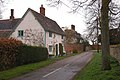
 Mid-nineteenth century housing near to Cardington - geograph.org.uk - 4509060.jpg 4,320 × 3,240; 3.89 MB
-
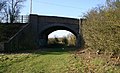 Old railway bridge on Southill Road - geograph.org.uk - 371587.jpg 635 × 388; 64 KB
-
 Pasture Farm from Southill Road - geograph.org.uk - 1834201.jpg 1,024 × 768; 120 KB
-
 RAF Cardington, Airship hangars - geograph.org.uk - 4508858.jpg 4,320 × 3,240; 4.19 MB
-
 Roundabout on Cambridge Road, Bedford - geograph.org.uk - 6627241.jpg 1,920 × 1,280; 1.18 MB
-
 Sheep alongside Southill Road - geograph.org.uk - 1834196.jpg 1,024 × 768; 109 KB
-
 Sheep and Sheds - geograph.org.uk - 1834191.jpg 1,024 × 768; 133 KB
-
 Southill Road - geograph.org.uk - 1834208.jpg 1,024 × 768; 140 KB
-
 Southill Road - geograph.org.uk - 4191223.jpg 1,600 × 1,067; 467 KB
-
 Southill Road towards Cardington - geograph.org.uk - 3350412.jpg 640 × 469; 53 KB
-
 Southill Road towards Old Warden - geograph.org.uk - 3350413.jpg 640 × 470; 43 KB
-
 Southill Road, Cardington - geograph.org.uk - 6629591.jpg 1,916 × 1,274; 1.53 MB
-
 Southill Road, Cardington - geograph.org.uk - 6629678.jpg 1,884 × 1,222; 1.55 MB
-
 Track into the enclosure within the moat - geograph.org.uk - 4191228.jpg 1,600 × 1,068; 671 KB
-
 Track north of Southill Road - geograph.org.uk - 799352.jpg 640 × 480; 86 KB
-

-
 Traditional telegraph pole on Southill Road, Cardington - geograph.org.uk - 6629676.jpg 1,868 × 1,196; 959 KB
-
 Trees round the moat - geograph.org.uk - 4191249.jpg 1,600 × 1,068; 514 KB
-

-
 Village Hall - geograph.org.uk - 3683006.jpg 1,600 × 1,067; 319 KB
-

-
 Bedford scenery - geograph.org.uk - 288797.jpg 640 × 480; 64 KB
-
 Blocked entrance to Hillfoot Farm - geograph.org.uk - 427962.jpg 640 × 480; 102 KB
-
 Field next to "The Gables" - geograph.org.uk - 427970.jpg 640 × 480; 93 KB
-

-
 Hedge and field next to Hillfoot Farm - geograph.org.uk - 427965.jpg 640 × 480; 119 KB
-
 Willington Quarry - geograph.org.uk - 288767.jpg 640 × 480; 84 KB


