Category:Caramoran
Jump to navigation
Jump to search
municipality of the Philippines in the province of Catanduanes  | |||||
| Upload media | |||||
| Instance of | |||||
|---|---|---|---|---|---|
| Location | Catanduanes, Bicol Region, PH | ||||
| Inception |
| ||||
| Population |
| ||||
| Area |
| ||||
| Elevation above sea level |
| ||||
| Electorate |
| ||||
| official website | |||||
 | |||||
Media in category "Caramoran"
The following 4 files are in this category, out of 4 total.
-
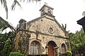 Caramoran Parish Church, Catanduanes.jpg 3,216 × 2,136; 2.83 MB
-
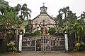 Church grounds of Caramoran, Catanduanes.jpg 3,216 × 2,136; 3.45 MB
-
 Flag of Caramoran, Catanduanes.png 1,200 × 700; 228 KB
-
 Ph locator catanduanes caramoran.png 300 × 250; 8 KB


