Category:Capenhurst Lane bridge
Jump to navigation
Jump to search
| Object location | | View all coordinates using: OpenStreetMap |
|---|
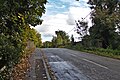
Carries Capenhurst Lane over the Merseyrail lines at Capenhurst railway station. Designated CRR1/18 and 5.25 miles frnm the datum at Chester railway station.
Media in category "Capenhurst Lane bridge"
The following 8 files are in this category, out of 8 total.
-
 Bridge, Capenhurst Railway Station (geograph 2986982).jpg 1,024 × 683; 152 KB
-
 Capenhurst Lane bridge 1.jpg 4,609 × 3,428; 27.28 MB
-
 Capenhurst Lane bridge 2.jpg 4,925 × 3,280; 25.11 MB
-
 Capenhurst Lane bridge 3.jpg 4,815 × 3,368; 23.71 MB
-
 Capenhurst Lane bridge 4.jpg 4,947 × 3,319; 21.04 MB
-
 Capenhurst Lane bridge 5.jpg 4,883 × 3,100; 17.97 MB
-
 Capenhurst Lane bridge 6.jpg 4,954 × 3,301; 22.45 MB
-
 View south from Capenhurst Lane bridge.jpg 5,198 × 3,462; 26.27 MB
.jpg)


