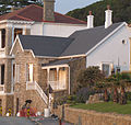
Category:Canty Bay House, Muizenberg
Jump to navigation
Jump to search
| This category shows a South African Protected Site with SAHRA file reference 9/2/081/0040. |
| Camera location | | View all coordinates using: OpenStreetMap |
|---|
Media in category "Canty Bay House, Muizenberg"
The following 11 files are in this category, out of 11 total.
-
 Canty Bay House 01.jpg 1,840 × 1,744; 795 KB
-
 Canty Bay House Muizenberg 01.jpg 5,248 × 3,936; 4.01 MB
-
 Canty Bay House Muizenberg 02.jpg 5,248 × 3,936; 5.49 MB
-
 Canty Bay House Muizenberg 03.jpg 5,248 × 3,936; 3.87 MB
-
 Canty Bay House Muizenberg 20.jpg 5,248 × 3,936; 4.13 MB
-
 Canty Bay House Muizenberg 21.jpg 3,936 × 5,248; 4.22 MB
-
 Canty Bay House Muizenberg Fish Eye.jpg 6,144 × 6,144; 5.88 MB
-
 Canty Bay House Muizenberg Panorama.jpg 6,468 × 2,038; 2.32 MB
-
 Canty Bay House Muizenberg.jpg 3,450 × 5,241; 3.57 MB
-
 Canty Bay House.jpg 3,805 × 2,539; 4.15 MB
-
 Canty House,196 Main Road, Muizenberg.jpg 3,128 × 2,686; 2.77 MB


