Category:Cannon Point Walkway
Jump to navigation
Jump to search
hiking trail in New Zealand  | |||||
| Upload media | |||||
| Instance of | |||||
|---|---|---|---|---|---|
| Located in protected area | |||||
| Location | Upper Hutt City, Wellington Region, New Zealand | ||||
 | |||||
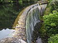
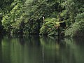
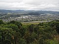
The Cannonpoint Walkway is an intermediate level trail through the hills north of Upper Hutt, in the Wellington region of New Zealand. The trail starts from Tulsa Park and zigzags uphill through private land and Akatawara Forest to the Cannon Point trig, where there are views over the Hutt Valley. It then continues alongside old forestry roads to the north and descends to the historic Birchville Dam. This dam, built in 1929, supplied water to Upper Hutt until the Kaitoke Scheme started in 1954.
Media in category "Cannon Point Walkway"
The following 15 files are in this category, out of 15 total.
-
 Birchville Dam spillway.jpg 4,320 × 3,240; 3.08 MB
-
 Cannnon Point walkway scenes - MC 01.jpg 3,888 × 5,184; 9.47 MB
-
 Cannnon Point walkway scenes - MC 02.jpg 5,184 × 3,888; 9.42 MB
-
 Cannnon Point walkway scenes - MC 04.jpg 5,184 × 3,888; 9.54 MB
-
 Cannnon Point walkway scenes - MC 05.jpg 3,888 × 5,184; 9.09 MB
-
 Cannnon Point walkway scenes - MC 06.jpg 5,184 × 3,888; 8.77 MB
-
 Cannnon Point walkway scenes - MC 07.jpg 5,184 × 3,888; 9.18 MB
-
 Cannnon Point walkway scenes - MC 08.jpg 5,184 × 3,888; 7.59 MB
-
 Cannnon Point walkway scenes - MC 09.jpg 5,184 × 3,888; 8.63 MB
-
 Cannnon Point walkway scenes - MC 10.jpg 3,888 × 5,184; 7.8 MB
-
 Cannnon Point walkway scenes - MC 11.jpg 5,184 × 3,888; 9.09 MB
-
 Cannnon Point walkway scenes - MC 12.jpg 5,184 × 3,888; 9.47 MB
-
 Cannnon Point walkway scenes - MC 13.jpg 5,184 × 3,888; 9.47 MB
-
 Cannnon Point walkway scenes - MC 14.jpg 5,184 × 3,888; 9.05 MB
-
 Cannon Point Trig.jpg 4,608 × 3,456; 12.4 MB


