Category:Cannerweg 342, Maastricht
Jump to navigation
Jump to search
| Object location | | View all coordinates using: OpenStreetMap |
|---|
building in Maastricht, Netherlands  | |||||
| Upload media | |||||
| Instance of | |||||
|---|---|---|---|---|---|
| Location | Biesland, Maastricht-Zuidwest, Maastricht, Limburg, Netherlands | ||||
| Street address |
| ||||
| Located on street | |||||
| Connects with |
| ||||
| Heritage designation |
| ||||
 | |||||
|
This is a category about rijksmonument number 27948
|
| Address |
|
Media in category "Cannerweg 342, Maastricht"
The following 6 files are in this category, out of 6 total.
-
 340-342, exterieur aanzicht - Maastricht - 20148254 - RCE.jpg 1,200 × 965; 295 KB
-
 340-342, exterieur aanzicht - Maastricht - 20148255 - RCE.jpg 1,200 × 958; 219 KB
-
 340-342, exterieur aanzicht - Maastricht - 20148256 - RCE.jpg 1,200 × 957; 264 KB
-
 340-342, exterieur aanzicht - Maastricht - 20148258 - RCE.jpg 1,200 × 964; 305 KB
-
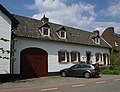 Maastricht - rijksmonument 27948 - Cannerweg 342 20100515.jpg 800 × 615; 212 KB
-
 Overzicht - Maastricht - 20382915 - RCE.jpg 1,200 × 1,191; 277 KB


