Category:Can Padró (Polinyà)
Jump to navigation
Jump to search
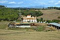
Català: Can Padró (Polinyà)
This is a category about a building listed in the Catalan heritage register as Bé Cultural d'Interès Local (BCIL) under the reference IPA-27559. |
| Object location | | View all coordinates using: OpenStreetMap |
|---|
masia in Polinyà (Vallès Occidental, Catalonia)  | |||||
| Upload media | |||||
| Instance of | |||||
|---|---|---|---|---|---|
| Location | Polinyà, Vallès Occidental, Àmbit metropolità de Barcelona, Barcelona Province, Catalonia | ||||
| Street address |
| ||||
| Architectural style | |||||
| Heritage designation |
| ||||
| Elevation above sea level |
| ||||
 | |||||
Media in category "Can Padró (Polinyà)"
This category contains only the following file.
-
 Can Padró.jpg 6,016 × 4,000; 2.67 MB