Category:Campbell Island (historical images)
Jump to navigation
Jump to search
Media in category "Campbell Island (historical images)"
The following 17 files are in this category, out of 17 total.
-
 Campbell Island TOV expedition 1.JPG 425 × 228; 26 KB
-
 Campbell Island TOV expedition 2.JPG 423 × 231; 90 KB
-
 FMIB 50746 Perseverance Harbour, Campbell Island.jpeg 1,779 × 675; 370 KB
-

-

-
 FMIB 50791 Geological Map of Campbell Island.jpeg 1,218 × 1,323; 228 KB
-
 FMIB 50792 Panoramic Sketch of Campbell Island, from the top of Mount Paris.jpeg 1,131 × 359; 102 KB
-
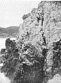
 FMIB 50793 Western Cliffs of Limestone, Campbell Island.jpeg 780 × 561; 158 KB
-
-
 FMIB 50795 Mount Menhir, Campbell Island, from the East.jpeg 779 × 588; 123 KB
-

-
 FMIB 50797 Sill of Basalt, North-West Bay, Campbell Island.jpeg 736 × 517; 147 KB
-
 FMIB 50798 Summit of Lyall Pyramid, Campbell Island (1,273 ft high).jpeg 579 × 727; 143 KB
-

-
 FMIB 50818 Sketch Map of Campbell Island.jpeg 1,209 × 1,324; 166 KB
-
 P239 Voyage of Discovery Ross Vol 1.jpg 4,012 × 2,457; 1.9 MB
-
 Snipegodwitbuller2.jpg 330 × 448; 64 KB


_with_Poa_litorosa_nd_Bulbinella.jpeg)


.jpeg)


