Category:Cambeak
Jump to navigation
Jump to search
| Upload media | |||||
| Instance of | |||||
|---|---|---|---|---|---|
| Location | St Gennys, Cornwall, South West England, England | ||||
 | |||||
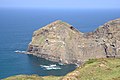
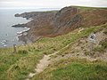
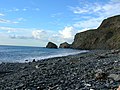
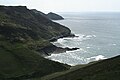
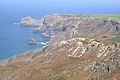
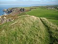
Cambeak is a headland on the north coast of Cornwall a quarter of a mile west of Crackington Haven.
Media in category "Cambeak"
The following 17 files are in this category, out of 17 total.
-
 Cambeak - geograph.org.uk - 1490511.jpg 640 × 426; 84 KB
-
 Cambeak - geograph.org.uk - 53343.jpg 640 × 480; 143 KB
-
 Cambeak from Bray's Point - geograph.org.uk - 1490384.jpg 640 × 426; 57 KB
-
 Cambeak Headland - geograph.org.uk - 1490474.jpg 640 × 426; 93 KB
-
 Cliff Path at Pencannow Point - geograph.org.uk - 1773414.jpg 640 × 427; 111 KB
-
 Crackington Haven, lawn and beach - geograph.org.uk - 1466138.jpg 640 × 480; 79 KB
-

-

-
 Rusey Cliff - geograph.org.uk - 1002536.jpg 640 × 614; 110 KB
-
 Rusey Cliff - geograph.org.uk - 1565001.jpg 640 × 480; 85 KB
-
-
 St Gennys, Cambeak - geograph.org.uk - 1267791.jpg 640 × 427; 372 KB
-
-
 Steep path towards Cambeak - geograph.org.uk - 1490427.jpg 426 × 640; 122 KB
-
 The View from High Cliff - geograph.org.uk - 1490703.jpg 640 × 426; 89 KB
-
 Tremoutha Haven - geograph.org.uk - 563765.jpg 640 × 480; 117 KB
-
 View north from High Cliff - geograph.org.uk - 1561006.jpg 640 × 480; 102 KB


