Category:California State Route 52
Jump to navigation
Jump to search
highway in California    | |||||
| Upload media | |||||
| Instance of | |||||
|---|---|---|---|---|---|
| Location | San Diego County, California, Pacific States Region | ||||
| Transport network |
| ||||
| Owned by | |||||
| Maintained by | |||||
| Start time |
| ||||
| Inception |
| ||||
| Length |
| ||||
| Terminus | |||||
| |||||
- California State Route 52 — a state highway in San Diego County, California.
- The route extends from La Jolla Parkway at Interstate 5 (I-5) in La Jolla, San Diego, eastward to SR 67 in Santee.
Media in category "California State Route 52"
The following 8 files are in this category, out of 8 total.
-
 CA SR 52 Opening.JPG 1,468 × 980; 466 KB
-
 California 52.svg 385 × 401; 13 KB
-
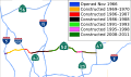 California State Route 52 history.svg 1,027 × 609; 399 KB
-
 California state route 52.JPG 2,976 × 1,924; 2.08 MB
-
 California State Route 52.svg 5,137 × 3,046; 693 KB
-
 Mount Soledad - Looking East (Highway 52).jpg 8,043 × 6,032; 32.85 MB
-
 Scripps Ranch, San Diego, CA, USA - panoramio (1).jpg 2,592 × 1,456; 647 KB
-
 Scripps Ranch, San Diego, CA, USA - panoramio (2).jpg 2,592 × 1,456; 652 KB


.jpg)
.jpg)
.jpg)