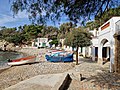
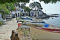
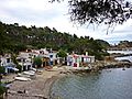
Category:Cala s'Alguer
Jump to navigation
Jump to search
Català: Cala s'Alguer (Palamós)
This is a category about a historical area listed in the Catalan heritage register of Béns Culturals d'Interès Nacional and the Spanish heritage register of Bienes de Interés Cultural under the reference RI-53-0000481. |
| Object location | | View all coordinates using: OpenStreetMap |
|---|
cultural property in Palamós, Spain .jpg) | |||||
| Upload media | |||||
| Instance of |
| ||||
|---|---|---|---|---|---|
| Location | Palamós, Baix Empordà, Province of Girona, Catalonia | ||||
| Located in or next to body of water | |||||
| Architectural style | |||||
| Heritage designation | |||||
| Width |
| ||||
| Length |
| ||||
| Population |
| ||||
| Elevation above sea level |
| ||||
 | |||||
Media in category "Cala s'Alguer"
The following 50 files are in this category, out of 50 total.
-
 140 Barraca de la Cadena (s'Alguer, Palamós).jpg 2,816 × 2,112; 2.1 MB
-
 141 S'Alguer (Palamós).jpg 2,816 × 2,112; 2.03 MB
-
 142 S'Alguer (Palamós), a l'esquerra la barraca de la Cadena.jpg 2,816 × 2,112; 1.8 MB
-
 143 Barraques de s'Alguer (Palamós).jpg 2,816 × 2,112; 2.1 MB
-
 144 Barraques de s'Alguer (Palamós).jpg 2,816 × 2,112; 1.63 MB
-
 Cala s'Alguer 2022-10-24 10.34.14.jpg 4,000 × 3,000; 4.53 MB
-
 Cala s'Alguer 2022-10-24 10.34.21.jpg 4,000 × 3,000; 3.76 MB
-
 Cala s'Alguer 2022-10-24 10.35.52.jpg 4,622 × 2,884; 3.01 MB
-
 Cala s'Alguer 2022-10-24 10.49.29.jpg 4,000 × 3,000; 5.8 MB
-
 Cala s'Alguer 2022-10-24 10.50.11.jpg 4,000 × 3,000; 4.47 MB
-
 42 S'Alguer (Palamós), des del camí de ronda.jpg 2,816 × 2,112; 2.48 MB
-
 44 Barraca de la Cadena (s'Alguer, Palamós).jpg 2,816 × 2,112; 1.72 MB
-
 51 Els esculls de s'Alguer i la punta de Castell (Palamós), des del camí de ronda.jpg 2,112 × 2,816; 2.89 MB
-
 52 S'Alguer (Palamós).jpg 2,816 × 2,112; 3.32 MB
-
 53 S'Alguer (Palamós).jpg 2,816 × 2,112; 3.07 MB
-
 54 S'Alguer (Palamós).jpg 2,816 × 2,112; 1.87 MB
-
 55 S'Alguer (Palamós).jpg 2,816 × 2,112; 2.39 MB
-
 69 S'Alguer (Palamós).jpg 2,816 × 2,112; 3.17 MB
-
 70 Esculls a Cala s'Alguer (Palamós).jpg 2,816 × 2,112; 2.35 MB
-
 72 S'Alguer i la punta de Castell (Palamós), des del camí de ronda.jpg 2,816 × 2,112; 2.89 MB
-
 Cala s'Alguer (Palamós) - 1.jpg 3,872 × 2,592; 756 KB
-
 Cala s'Alguer (Palamós) - 2.jpg 2,733 × 1,830; 3.28 MB
-
 Cala s'Alguer, 3.jpg 4,608 × 2,592; 5.02 MB
-
 Cala s'alguer-Palamos (1).jpg 4,170 × 2,793; 12.65 MB
-
 Cala s'alguer-Palamos (10).jpg 4,288 × 2,848; 9.23 MB
-
 Cala s'alguer-Palamos (11).jpg 4,152 × 2,757; 10.2 MB
-
 Cala s'alguer-Palamos (12).jpg 2,793 × 4,103; 8.13 MB
-
 Cala s'alguer-Palamos (13).jpg 4,288 × 2,848; 11.79 MB
-
 Cala s'alguer-Palamos (14).jpg 4,288 × 2,848; 8.13 MB
-
 Cala s'alguer-Palamos (2).jpg 2,759 × 4,014; 9.26 MB
-
 Cala s'alguer-Palamos (3).jpg 4,288 × 2,848; 10.11 MB
-
 Cala s'alguer-Palamos (9).jpg 3,947 × 2,698; 10.1 MB
-
 Cala s'alguer-Palamos.jpg 4,288 × 2,848; 9.13 MB
-
 Cala s'Alguer.jpg 4,608 × 3,072; 12.56 MB
-
 CALA SALGUER.jpg 480 × 640; 123 KB
-
 Cami de ronda - panoramio.jpg 3,072 × 2,304; 676 KB
-
 Camide ronda s'alguer - panoramio.jpg 3,140 × 1,091; 622 KB
-
 Cases de pescadors s'Alguer.jpg 3,648 × 2,736; 4.64 MB
-
 Detall paisatgístic (camí de ronda de Palamós a les Cales de Cala Estreta) - panoramio.jpg 1,920 × 1,080; 1.03 MB
-
 L'aigua a la Cala s'Alguer.jpg 4,608 × 3,072; 14.86 MB
-
 Palamós - Cala S'Alguer i Platja de Castell - Panorama.jpg 3,378 × 726; 394 KB
-
 Palamós - panoramio.jpg 1,200 × 773; 209 KB
-
 Palamós, Province of Girona, Spain - panoramio (2).jpg 3,264 × 2,448; 2.96 MB
-
 Palamós, Province of Girona, Spain - panoramio (3).jpg 3,264 × 2,448; 3.34 MB
-
 Palamós, Province of Girona, Spain - panoramio (4).jpg 3,264 × 2,448; 3.23 MB
-
 PL-CT-17003-189.jpg 640 × 480; 125 KB
-
 S'Alguer - panoramio (1).jpg 1,950 × 1,300; 1.33 MB
-
 S'Alguer - panoramio (2).jpg 1,950 × 1,300; 1.53 MB
-
 S'alguer - panoramio.jpg 3,072 × 2,304; 667 KB
-
 S'Alguer - panoramio.jpg 1,950 × 1,300; 1.47 MB
.jpg)
.jpg)
,_a_l%27esquerra_la_barraca_de_la_Cadena.jpg)
.jpg)
.jpg)


,_des_del_cam%C3%AD_de_ronda.jpg)
.jpg)
,_des_del_cam%C3%AD_de_ronda.jpg)
.jpg)
.jpg)
.jpg)
.jpg)
.jpg)
.jpg)
,_des_del_cam%C3%AD_de_ronda.jpg)
_-_1.jpg)
_-_2.jpg)

.jpg)
.jpg)
.jpg)
.jpg)
.jpg)
.jpg)
.jpg)
.jpg)


_-_panoramio.jpg)


.jpg)
.jpg)
.jpg)

.jpg)
.jpg)

