Category:Cal Sabater (Anglès)
Jump to navigation
Jump to search
| Object location | | View all coordinates using: OpenStreetMap |
|---|
building in Anglès, Catalonia ,_cara_nord.jpg) Arcada de Can Verdaguer, a Cal Sabater, cara nord | |||||
| Upload media | |||||
| Instance of | |||||
|---|---|---|---|---|---|
| Location | Anglès, Selva, Comarques Gironines, Catalonia | ||||
| Street address |
| ||||
| Heritage designation |
| ||||
 | |||||
Català: Cal Sabater (Anglès)
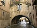
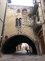
This is a category about a building listed in the Catalan heritage register as Bé Cultural d'Interès Local (BCIL) under the reference IPA-26607. |
Media in category "Cal Sabater (Anglès)"
The following 9 files are in this category, out of 9 total.
-
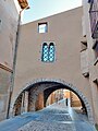 71 Arcada de Can Verdaguer, Cal Sabater, c. d'Avall 36 (Anglès), cara nord.jpg 3,120 × 4,160; 7.2 MB
-
 72 Arcada de Can Verdaguer, Cal Sabater, c. d'Avall 36 (Anglès).jpg 4,160 × 3,120; 7.19 MB
-
 75 Arcada de Can Verdaguer, Cal Sabater, c. d'Avall 36 (Anglès), cara sud.jpg 3,120 × 4,160; 7.44 MB
-
 Angles IMG 2429.jpg 900 × 675; 180 KB
-
 Arcada de Can Verdaguer d'Anglès 1.jpg 2,368 × 3,200; 2.43 MB
-
 Arcada de Can Verdaguer d'Anglès 2.jpg 2,368 × 3,200; 3.02 MB
-
 Arcada de Can Verdaguer.jpg 3,456 × 4,608; 3.61 MB
-
 Cal Sabater, arcada de Can Verdaguer.jpg 2,448 × 3,264; 2.89 MB
-
 Carrers d'Anglès.jpeg 1,547 × 720; 217 KB
.jpg)
,_cara_sud.jpg)


