Category:Cal Pla (Porrera)
Jump to navigation
Jump to search
Català: Cal Pla (Porrera)
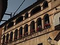
This is a category about a building listed in the Catalan heritage register as Bé Cultural d'Interès Local (BCIL) under the reference IPA-43564. |
| Object location | | View all coordinates using: OpenStreetMap |
|---|
,_Cal_Pla,_pl._Esgl%C3%A9sia.jpg) | |||||
| Upload media | |||||
| Instance of | |||||
|---|---|---|---|---|---|
| Location | Porrera, Priorat, Camp de Tarragona, Tarragona Province, Catalonia | ||||
| Street address |
| ||||
| Heritage designation |
| ||||
| Inception |
| ||||
| Elevation above sea level |
| ||||
 | |||||
Media in category "Cal Pla (Porrera)"
This category contains only the following file.
-
 Porrera (48), Cal Pla, pl. Església.jpg 3,456 × 2,592; 1.04 MB