Category:Cal Bep del Pau
Jump to navigation
Jump to search
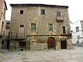
Català: Cal Bep del Pau (la Fuliola)
This is a category about a building listed in the Catalan heritage register as Bé Cultural d'Interès Local (BCIL) under the reference IPA-29766. |
| Object location | | View all coordinates using: OpenStreetMap |
|---|
house in La Fuliola, Spain  | |||||
| Upload media | |||||
| Instance of | |||||
|---|---|---|---|---|---|
| Location | La Fuliola, Urgell, Ponent, Lleida Province, Catalonia | ||||
| Street address |
| ||||
| Architectural style | |||||
| Heritage designation |
| ||||
| Inception |
| ||||
| Elevation above sea level |
| ||||
 | |||||
Media in category "Cal Bep del Pau"
The following 2 files are in this category, out of 2 total.
-
 CAL BEP DEL PAU - LA FULIOLA - IB-470.jpg 2,048 × 1,536; 1,002 KB
-
 CAL BEP DEL PAU - LA FULIOLA - IB-471.jpg 1,536 × 2,048; 1.01 MB
