Category:Cache County, Utah
Jump to navigation
Jump to search
Counties of Utah: Beaver · Box Elder · Cache · Carbon · Daggett · Davis · Duchesne · Emery · Garfield · Grand · Iron · Juab · Kane · Millard · Morgan · Piute · Rich · Salt Lake · San Juan · Sanpete · Sevier · Summit · Tooele · Uintah · Utah · Wasatch · Washington · Wayne · Weber
county in northern Utah, United States   | |||||
| Upload media | |||||
| Instance of | |||||
|---|---|---|---|---|---|
| Location | Utah | ||||
| Capital | |||||
| Inception |
| ||||
| Population |
| ||||
| Area |
| ||||
| Different from | |||||
| official website | |||||
 | |||||
English: Media related to Cache County, Utah, a county on the northern edge of Utah, United States.
Subcategories
This category has the following 12 subcategories, out of 12 total.
Media in category "Cache County, Utah"
The following 34 files are in this category, out of 34 total.
-
 0811-Tony Grove 1.JPG 3,648 × 2,736; 2.17 MB
-
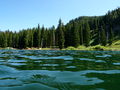 0811-Tony Grove 5.JPG 3,648 × 2,736; 2.2 MB
-
 ActaeaRubraBerries.jpg 1,350 × 937; 978 KB
-
 Adventure in logan 2.jpg 3,264 × 2,448; 3.32 MB
-
 Adventure in logan 3.jpg 3,264 × 2,448; 2.73 MB
-
 Adventure in logan 4.jpg 2,448 × 3,264; 4.21 MB
-
 Adventure in logan 5.jpg 3,264 × 2,448; 4.19 MB
-
 Adventure in logan 6.jpg 2,448 × 3,264; 3.41 MB
-
 Adventure in logan.jpg 3,264 × 2,448; 3.08 MB
-
 Bear River crossing, head of Cache Valley. Cache County, Utah. - NARA - 516658.jpg 3,000 × 2,380; 1.15 MB
-
 Bradley Swenson 2016 (Unsplash).jpg 2,448 × 3,264; 2.16 MB
-
 Brent2x2fondo.jpg 5,616 × 3,744; 5.21 MB
-
 Cherry Slopes X (136712881).jpeg 900 × 1,600; 609 KB
-
 Cherry Slopes Y (136712887).jpeg 1,600 × 900; 532 KB
-
 Cherry Slopes Z (136712885).jpeg 900 × 1,402; 480 KB
-
 Extinct soda spring basin, on Bear River, Utah - NARA - 516725.jpg 3,000 × 2,272; 1.78 MB
-
 Extinct soda spring basin. Cache County, Utah - NARA - 516731.jpg 3,000 × 2,300; 1.9 MB
-
 Hardware Ranch WMA, Hyrum, United States (Unsplash).jpg 2,500 × 1,667; 856 KB
-
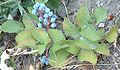 MahoniaRepensBerriesUtah.jpg 1,289 × 751; 786 KB
-
 NRCSUT03010 - Utah (6391)(NRCS Photo Gallery).jpg 2,100 × 1,500; 6.91 MB
-
 NRCSUT03010 - Utah (6391)(NRCS Photo Gallery).tif 2,100 × 1,500; 12.02 MB
-
 NRCSUT03040 - Utah (6449)(NRCS Photo Gallery).jpg 1,500 × 2,100; 5.93 MB
-
 NRCSUT03040 - Utah (6449)(NRCS Photo Gallery).tif 1,500 × 2,100; 12.02 MB
-
 NRCSUT03044 - Utah (6457)(NRCS Photo Gallery).jpg 2,100 × 1,500; 4.61 MB
-
 NRCSUT03044 - Utah (6457)(NRCS Photo Gallery).tif 2,100 × 1,500; 12.02 MB
-
 NRCSUT03048 - Utah (6465)(NRCS Photo Gallery).jpg 2,100 × 1,500; 6.03 MB
-
 NRCSUT03048 - Utah (6465)(NRCS Photo Gallery).tif 2,100 × 1,500; 12.02 MB
-
 Powder M (179512255).jpeg 2,048 × 597; 244 KB
-
 Rick's Spring, Cache Forest, Wasatch Mountains, UT 9-2011 (6842538057).jpg 1,498 × 1,997; 1.1 MB
-
 Toppled (136712883).jpeg 900 × 1,600; 613 KB
-
 Uinta-Wasatch-Cache National Forest, United States (Unsplash).jpg 4,096 × 2,734; 6.56 MB
-
 USA Cache County, Utah age pyramid.svg 520 × 600; 8 KB
-
 UT-23 in Mendon UT - panoramio.jpg 1,600 × 1,200; 432 KB
-
 West of Bear Lake, Utah, close to Idaho border - panoramio.jpg 3,456 × 2,592; 4.35 MB


.jpg)

.jpeg)
.jpeg)
.jpeg)


.jpg)

(NRCS_Photo_Gallery).jpg)
(NRCS_Photo_Gallery).jpg)
(NRCS_Photo_Gallery).jpg)
(NRCS_Photo_Gallery).jpg)
.jpg)
.jpeg)
.jpg)


.jpeg)