Category:Cachapoal River
Jump to navigation
Jump to search
river in Chile  | |||||
| Upload media | |||||
| Instance of | |||||
|---|---|---|---|---|---|
| Location | O'Higgins Region, Chile | ||||
| Length |
| ||||
| Origin of the watercourse |
| ||||
| Mouth of the watercourse | |||||
| Drainage basin | |||||
| Tributary | |||||
 | |||||
Media in category "Cachapoal River"
The following 54 files are in this category, out of 54 total.
-
 Alto-cachapoal-ch.svg 1,385 × 335; 71 KB
-
 Cachapoal 1900.jpg 747 × 474; 49 KB
-
 Cachapoal-5km-abajo-confluencia-c-cortaderal.png 280 × 320; 33 KB
-
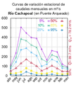 Cachapoal-en-puente-arqueado.png 280 × 320; 30 KB
-
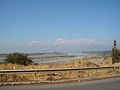 Cachapoal.jpg 1,632 × 1,224; 485 KB
-
 Campo en Pataguas Orilla al atardecer en invierno.jpg 2,592 × 1,456; 1.02 MB
-
 Canal desde Cachapoal. - panoramio.jpg 3,072 × 2,304; 2.14 MB
-
 Cerca del Puente Río Claro. - panoramio.jpg 3,072 × 2,304; 2.62 MB
-
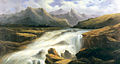
 Cerro en el nacimiento del río Cachapoal (1872).jpg 1,536 × 954; 342 KB
-
 Cerro Orocoipo y Río Cachapoal. - panoramio.jpg 3,072 × 2,304; 2.51 MB
-
 Chacalle. - panoramio.jpg 3,072 × 2,304; 2.45 MB
-
 Cipreses. - panoramio (16).jpg 3,072 × 2,304; 2.06 MB
-
 Cipreses. - panoramio (17).jpg 3,072 × 2,304; 2.56 MB
-
 Cipreses. - panoramio (18).jpg 2,304 × 3,072; 2.11 MB
-
 Coltauco, H-30. - panoramio - R.A.T.P. (11).jpg 3,072 × 2,304; 2.41 MB
-
 Coltauco, H-30. - panoramio - R.A.T.P. (27).jpg 3,072 × 2,304; 2.44 MB
-
 Coltauco, H-30. - panoramio - R.A.T.P. (28).jpg 3,072 × 2,304; 2.06 MB
-
 Coltauco, H-30. - panoramio - R.A.T.P. (4).jpg 2,304 × 3,072; 2.54 MB
-
 Coltauco, H-30. - panoramio - R.A.T.P. (5).jpg 3,072 × 2,304; 2.57 MB
-
 Coltauco, H-30. - panoramio - R.A.T.P. (8).jpg 3,072 × 2,304; 2.59 MB
-
 Coltauco, H-30. - panoramio.jpg 3,072 × 2,304; 2.53 MB
-
 Desde el Morro del Chivato. - panoramio (3).jpg 3,072 × 2,304; 2.13 MB
-
 Desde Puente Cachapoal. - panoramio.jpg 3,072 × 2,304; 2.64 MB
-
 Desde Puente Río Claro. - panoramio - R.A.T.P. (1).jpg 3,072 × 2,304; 2.49 MB
-
 ISS006-E-38584 - View of Chile.jpg 3,032 × 2,064; 1.23 MB
-
 Localidad de Coya.jpg 4,288 × 3,216; 2.27 MB
-
 Nacimiento del río Cachapoal (1872).jpg 689 × 1,518; 234 KB
-
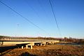 Nuevo Puente Coinco 01.JPG 4,608 × 3,072; 2.95 MB
-
 Nuevo Puente Coinco.JPG 4,608 × 3,072; 3.1 MB
-
 Pasarela desde Puente Cachapoal.jpg 3,072 × 2,304; 2.48 MB
-
 Pichidegua.JPG 3,264 × 2,448; 2.93 MB
-
 Puente captación de agua. - panoramio.jpg 3,072 × 2,304; 2.43 MB
-
 Reserva Rio Cipreses Hualo.jpg 1,200 × 803; 182 KB
-
 Ribera del Rio Cachapoal Peumo.jpg 2,592 × 1,456; 900 KB
-
 Rio Cachapoal aerial1 detail.jpg 3,008 × 2,000; 2.89 MB
-
 Rio Cachapoal aerial2 wide.jpg 3,008 × 2,000; 3.55 MB
-
 Rio Cachapoal aerial3.jpg 2,000 × 3,008; 2.77 MB
-
 Rio Cachapoal aerial4 detail.jpg 3,008 × 2,000; 2.21 MB
-
 Rio cachapoal2.jpg 560 × 298; 108 KB
-
 Río Cachapoal (1942).jpg 657 × 500; 279 KB
-
 Río Cachapoal desde el Orocoipo. - panoramio (1).jpg 3,072 × 2,304; 2.41 MB
-
 Río Cachapoal desde el Orocoipo. - panoramio.jpg 3,072 × 2,304; 2.25 MB
-
 Río Cachapoal desde Ruta del Acido. - panoramio.jpg 3,072 × 2,304; 2.02 MB
-
 Río Cachapoal en Coya.jpg 4,288 × 3,216; 2.68 MB
-
 Río Cachapoal y Canal Central Hidroeléctrica Sauzalito. - panoramio.jpg 3,072 × 2,304; 2.66 MB
-
 Río Cachapoal. - panoramio - R.A.T.P. (1).jpg 3,072 × 2,304; 2.65 MB
-
 Río Cachapoal. - panoramio - R.A.T.P. (2).jpg 3,072 × 2,304; 2.59 MB
-
 Río Cachapoal. - panoramio - R.A.T.P. (3).jpg 3,072 × 2,304; 2.57 MB
-
 Río Cachapoal. - panoramio - R.A.T.P..jpg 3,072 × 2,304; 2.54 MB
-
 Río Cachapoal. - panoramio.jpg 3,072 × 2,304; 2.02 MB
-

-
 Valle Cachapoal Chile - panoramio.jpg 6,290 × 3,500; 2.99 MB
-
 Vista al valle de Los Cipreses.jpg 4,640 × 3,480; 2.48 MB
-
 Water pipeline over Cachapoal River - panoramio - R.A.T.P. (1).jpg 3,072 × 2,304; 1.79 MB


.jpg)


.jpg)
.jpg)
.jpg)
.jpg)
.jpg)
.jpg)
.jpg)
.jpg)
.jpg)

.jpg)

.jpg)


.jpg)


.jpg)
.jpg)


.jpg)
.jpg)
.jpg)


.jpg)


.jpg)