Category:Cabane du Mont-Fort
Jump to navigation
Jump to search
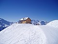
English: Alpine hut at the Mont Fort, canton Valais
Deutsch: Hütte am Mont Fort, Kanton Wallis
| Object location | | View all coordinates using: OpenStreetMap |
|---|
 | |||||
| Upload media | |||||
| Instance of | |||||
|---|---|---|---|---|---|
| Location | Bagnes, Val de Bagnes, Entremont District, Valais, Switzerland | ||||
| Owned by | |||||
| Inception |
| ||||
| Mountain range | |||||
| Elevation above sea level |
| ||||
| official website | |||||
 | |||||
Media in category "Cabane du Mont-Fort"
The following 4 files are in this category, out of 4 total.
-
 Cabane du Mont Fort 01.jpg 2,000 × 1,125; 796 KB
-
 Cabane du Mont Fort 02.jpg 2,000 × 1,125; 614 KB
-
 Mont Fort Cabane 082.JPG 2,048 × 1,536; 674 KB
-
 Mont Fort Cabane 084.JPG 2,048 × 1,536; 675 KB


