Category:Cabane des Dix
Jump to navigation
Jump to search
| Object location | | View all coordinates using: OpenStreetMap |
|---|
mountain hut of the Swiss Alpine Club  | |||||
| Upload media | |||||
| Instance of | |||||
|---|---|---|---|---|---|
| Location | Hérémence, Hérens District, Valais, Switzerland | ||||
| Owned by | |||||
| Inception |
| ||||
| Mountain range | |||||
| Elevation above sea level |
| ||||
| official website | |||||
 | |||||
Media in category "Cabane des Dix"
The following 13 files are in this category, out of 13 total.
-
 Blick nach Westen vom Col de Riedmatten.jpg 4,000 × 3,000; 4.82 MB
-
 Cabane des Dix - img 10596.jpg 2,496 × 1,664; 1.6 MB
-
 Cabane des Dix - img 10631.jpg 2,496 × 1,664; 1.86 MB
-
 Cabane des Dix 2.jpg 1,140 × 924; 142 KB
-
 Cabane des Dix Pas de Chèvres.jpg 4,000 × 3,000; 4.91 MB
-
 Cabane des Dix vom Col de Riedmatten.jpg 4,000 × 3,000; 5.11 MB
-
 Cabane des Dix über Glacier de Cheilon vom Col de Riedmatten.jpg 3,000 × 4,000; 3.93 MB
-
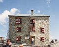
 Cabane des Dix.jpg 511 × 489; 187 KB
-
 Cabane des Vignettes, Haute Route (Swisstopo Landeskarte 50000 Blatt 283, 1968).tiff 1,955 × 1,490; 8.36 MB
-
 Dix Hut.jpg 3,072 × 2,304; 2.51 MB
-
 Mont Blanc de Cheilon.JPG 4,000 × 3,000; 1.57 MB
-
 Panorama West Pas de Chèvres.jpg 9,886 × 3,531; 11.02 MB
-
 Pas de Chèvres Glacier de Cheilon Cabane des Dix.jpg 4,000 × 3,000; 4.89 MB


