Category:Ca n'Oriol (Rubí)
Jump to navigation
Jump to search
| Object location | | View all coordinates using: OpenStreetMap |
|---|
masia in Rubí (Vallès Occidental, Catalonia)  | |||||
| Upload media | |||||
| Instance of | |||||
|---|---|---|---|---|---|
| Location | Ca n'Oriol, Rubí, Barcelona Province, Catalonia | ||||
| Architectural style | |||||
| Heritage designation |
| ||||
 | |||||
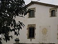
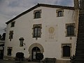
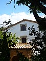
Català: Ca n'Oriol (Rubí). Masia d'estil gòtic tardà, al davant encara s'hi conserva l'era, que forma part d'un parc públic.
This is a category about a building listed in the Catalan heritage register as Bé Cultural d'Interès Local (BCIL) under the reference IPA-27639. |
Subcategories
This category has the following 2 subcategories, out of 2 total.
E
- Era de Ca n'Oriol (9 F)
Media in category "Ca n'Oriol (Rubí)"
The following 12 files are in this category, out of 12 total.
-
 178 Ca n'Oriol.jpg 2,272 × 1,704; 955 KB
-
 179 Ca n'Oriol.jpg 2,272 × 1,704; 1.02 MB
-
 180 Ca n'Oriol.jpg 2,272 × 1,704; 928 KB
-
 181 Ca n'Oriol.jpg 2,272 × 1,704; 880 KB
-
 189 Ca n'Oriol.jpg 2,272 × 1,704; 879 KB
-
 190 Ca n'Oriol, rellotge de sol.jpg 1,704 × 2,272; 868 KB
-
 191 Ca n'Oriol.jpg 2,272 × 1,704; 908 KB
-
 192 Ca n'Oriol, detall.jpg 1,704 × 2,272; 967 KB
-
 Ca n'Oriol P1510083.jpg 3,072 × 2,304; 3.38 MB
-
 Ca n'Oriol P1510084.jpg 3,072 × 2,304; 3.3 MB
-
 Ca n'Oriol P1510085.jpg 2,304 × 3,072; 3.35 MB
-
 Ca n'Oriol P1510086.jpg 3,072 × 2,304; 3.28 MB


