Category:Burton Agnes
Jump to navigation
Jump to search
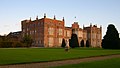
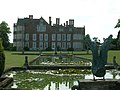
English: Burton Agnes is a village and civil parish in the East Riding of Yorkshire, England. It is situated on the A614 mid way between Driffield and Bridlington. Places of interest include an Elizabethan Manor House, Burton Agnes Hall and a Norman Manor House, Burton Agnes Manor House.
Norsk bokmål: Burton Agnes er en landsby i East Riding of Yorkshire, England. Den ligger ved A614, midt mellom Driffield og Bridlington.
village and civil parish in East Riding of Yorkshire, UK Mar2006.jpg) | |||||
| Upload media | |||||
| Instance of | |||||
|---|---|---|---|---|---|
| Location | East Riding of Yorkshire, Yorkshire and the Humber, England | ||||
| Population |
| ||||
 | |||||
Subcategories
This category has the following 10 subcategories, out of 10 total.
B
- Burton Agnes Manor House (3 F)
- Burton Agnes railway station (7 F)
- Burton Agnes War Memorial (2 F)
G
- Gransmoor (41 F)
H
- Hedges in Burton Agnes (2 F)
M
- St Martin's Church, Burton Agnes (11 F)
T
- Thornholme (19 F)
- Trees in Burton Agnes (23 F)
Media in category "Burton Agnes"
The following 200 files are in this category, out of 740 total.
(previous page) (next page)-
 A bend in Rudston Road - geograph.org.uk - 4161581.jpg 640 × 480; 69 KB
-
 A bend in the A614 - geograph.org.uk - 4160096.jpg 640 × 452; 94 KB
-
 A bridleway towards Woodside Farm - geograph.org.uk - 2748087.jpg 800 × 600; 163 KB
-
 A field in Gransmoor Wood - geograph.org.uk - 4795943.jpg 4,608 × 3,456; 4.03 MB
-
 A gas installation on Wold Gate (road) - geograph.org.uk - 2164765.jpg 800 × 600; 317 KB
-
 A Green Lane towards Thornholme - geograph.org.uk - 2197066.jpg 800 × 600; 203 KB
-
 A Green Lane towards Thornholme - geograph.org.uk - 2197074.jpg 800 × 600; 209 KB
-
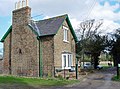 A house on Rudston Road, Burton Agnes - geograph.org.uk - 803485.jpg 640 × 474; 223 KB
-

-
 A misty day on Thornholme Field - geograph.org.uk - 5979363.jpg 1,024 × 768; 124 KB
-
 A very muddy path^ - geograph.org.uk - 6653733.jpg 1,024 × 768; 270 KB
-
 A very wet paddock at Woodside Farm - geograph.org.uk - 4795959.jpg 4,608 × 3,456; 4.28 MB
-
 A614 entering Thornholme - geograph.org.uk - 4316271.jpg 1,600 × 1,200; 236 KB
-
 A614 heading north east - geograph.org.uk - 4171949.jpg 640 × 480; 61 KB
-
 A614 heading north east - geograph.org.uk - 4171960.jpg 640 × 480; 67 KB
-
 A614 heading south west - geograph.org.uk - 4356739.jpg 640 × 480; 79 KB
-
 A614 into Burton Agnes - geograph.org.uk - 4160156.jpg 640 × 480; 60 KB
-
 A614 towards Bridlington - geograph.org.uk - 4171944.jpg 640 × 480; 54 KB
-
 A614 towards Bridlington - geograph.org.uk - 4171956.jpg 640 × 480; 64 KB
-
 A614 towards Driffield - geograph.org.uk - 4160088.jpg 640 × 436; 71 KB
-
 A614 towards Driffield - geograph.org.uk - 4160145.jpg 640 × 480; 74 KB
-
 A614 towards Driffield - geograph.org.uk - 4356749.jpg 640 × 480; 63 KB
-
 A614, Burton Agnes - geograph.org.uk - 5429766.jpg 640 × 426; 62 KB
-
 A614, Dunning Crofts - geograph.org.uk - 4171953.jpg 640 × 480; 34 KB
-
 A614, Thornholme - geograph.org.uk - 4160080.jpg 640 × 480; 54 KB
-
 A614, Thornholme - geograph.org.uk - 5133297.jpg 640 × 480; 68 KB
-
 Access road and bridleway to Woodside Farm - geograph.org.uk - 4795955.jpg 4,608 × 3,456; 5.08 MB
-
 Access road to Oak Tree Farm - geograph.org.uk - 5218960.jpg 2,300 × 1,722; 1.91 MB
-
 Approaching road junction and gas installation - geograph.org.uk - 5219584.jpg 2,262 × 1,670; 1.6 MB
-

-
 Arable crop at the top of Thornholme Field - geograph.org.uk - 6538648.jpg 1,600 × 1,200; 594 KB
-

-
 Back Lane - geograph.org.uk - 4160707.jpg 640 × 480; 87 KB
-
 Back Lane - geograph.org.uk - 4160925.jpg 640 × 480; 69 KB
-
 Back Lane - geograph.org.uk - 4160939.jpg 640 × 480; 68 KB
-
 Back Lane - geograph.org.uk - 4160953.jpg 640 × 480; 93 KB
-
 Back Lane heading north west - geograph.org.uk - 4160919.jpg 640 × 480; 75 KB
-
 Back Lane, Burton Agnes - geograph.org.uk - 4160693.jpg 640 × 480; 103 KB
-
 Bales and field, Thornholme Field - geograph.org.uk - 4171910.jpg 640 × 480; 56 KB
-

-
 Bank beside drain - geograph.org.uk - 6453402.jpg 800 × 600; 153 KB
-
 Barley at the top of Thornholme Field - geograph.org.uk - 6538659.jpg 1,600 × 1,200; 629 KB
-
 Barley field on the south side of Woldgate - geograph.org.uk - 6538601.jpg 1,600 × 1,200; 546 KB
-
 Battered ash - geograph.org.uk - 4312961.jpg 1,024 × 768; 206 KB
-
-
 Bend in Main Street (A614) - geograph.org.uk - 4160239.jpg 640 × 450; 82 KB
-
 Big field - geograph.org.uk - 5416897.jpg 640 × 426; 22 KB
-
 Biofuel crop - geograph.org.uk - 5403195.jpg 640 × 296; 34 KB
-
 Biofuel crop - geograph.org.uk - 5403196.jpg 640 × 327; 27 KB
-
 Biofuel crop - geograph.org.uk - 5416878.jpg 640 × 426; 30 KB
-
 Box pews in Burton Agnes church - geograph.org.uk - 4591254.jpg 1,067 × 1,600; 1.12 MB
-
 Bridleway to Gransmoor Wood - geograph.org.uk - 5568143.jpg 1,024 × 768; 214 KB
-
 Bridleway to Gransmoor Wood - geograph.org.uk - 5568147.jpg 1,024 × 768; 147 KB
-
 Bridleway to Woodside Farm from Gransmoor - geograph.org.uk - 4796848.jpg 4,608 × 3,456; 4.15 MB
-
 Burton Agnes - geograph.org.uk - 463221.jpg 470 × 640; 128 KB
-
 Burton Agnes Biomass Plant - geograph.org.uk - 5963645.jpg 1,024 × 768; 225 KB
-
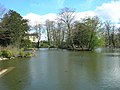 Burton Agnes Duck Pond - geograph.org.uk - 1240963.jpg 640 × 480; 90 KB
-
 Burton Agnes Duck Pond.jpg 640 × 480; 99 KB
-
 Burton Agnes Field - geograph.org.uk - 1240910.jpg 640 × 480; 73 KB
-
 Burton Agnes Field - geograph.org.uk - 1409288.jpg 640 × 480; 71 KB
-
 Burton Agnes Field - geograph.org.uk - 142950.jpg 640 × 480; 68 KB
-
 Burton Agnes Field - geograph.org.uk - 5136470.jpg 640 × 480; 94 KB
-
 Burton Agnes Hall - gatehouse - geograph.org.uk - 6481435.jpg 1,800 × 1,200; 412 KB
-
 Burton Agnes Hall - geograph.org.uk - 1933174.jpg 640 × 480; 73 KB
-
 Burton Agnes Hall - geograph.org.uk - 2270010.jpg 640 × 428; 91 KB
-
 Burton Agnes Hall - geograph.org.uk - 4359714.jpg 2,238 × 1,502; 546 KB
-
 Burton Agnes Hall - geograph.org.uk - 4359724.jpg 2,213 × 1,660; 591 KB
-
 Burton Agnes Hall - geograph.org.uk - 4359735.jpg 2,196 × 1,250; 360 KB
-
 Burton Agnes Hall - geograph.org.uk - 4359746.jpg 1,862 × 959; 239 KB
-
 Burton Agnes Hall - geograph.org.uk - 4494773.jpg 640 × 490; 214 KB
-
 Burton Agnes Hall - geograph.org.uk - 4912779.jpg 1,742 × 1,147; 436 KB
-
 Burton Agnes Hall - giant chess set - geograph.org.uk - 6464445.jpg 1,799 × 1,199; 403 KB
-
 Burton agnes Hall - the donkey wheel - geograph.org.uk - 1983639.jpg 480 × 640; 81 KB
-
 Burton Agnes Hall and grounds - geograph.org.uk - 6464442.jpg 1,799 × 1,199; 363 KB
-

-
 Burton Agnes Hall from the walled garden - geograph.org.uk - 4082173.jpg 3,262 × 2,330; 3.11 MB
-
 Burton Agnes Hall gatehouse - geograph.org.uk - 4912772.jpg 1,671 × 1,141; 381 KB
-
 Burton Agnes Hall through the arch - geograph.org.uk - 4494767.jpg 640 × 479; 218 KB
-
 Burton Agnes Hall, East elevation - geograph.org.uk - 1933179.jpg 640 × 480; 80 KB
-

-
 Burton Agnes Level Crossing - geograph.org.uk - 1256525.jpg 640 × 480; 50 KB
-
 Burton Agnes Level Crossing - geograph.org.uk - 4312945.jpg 1,024 × 768; 161 KB
-
 Burton Agnes level crossing - geograph.org.uk - 5431830.jpg 640 × 480; 111 KB
-
 Burton Agnes level crossing.jpg 640 × 480; 101 KB
-
 Burton Agnes Moor - geograph.org.uk - 5365010.jpg 640 × 426; 52 KB
-
 Burton Agnes Moor - geograph.org.uk - 5403184.jpg 640 × 348; 31 KB
-
 Burton Agnes Moor - geograph.org.uk - 5403186.jpg 640 × 348; 24 KB
-
 Burton Agnes Moor - geograph.org.uk - 5416891.jpg 640 × 388; 33 KB
-
 Burton Agnes Moor - geograph.org.uk - 5416893.jpg 640 × 426; 30 KB
-
 Burton Agnes pond - geograph.org.uk - 2751170.jpg 800 × 600; 131 KB
-
 Burton Agnes Stud Farm - geograph.org.uk - 1256549.jpg 640 × 480; 64 KB
-
 Burton Agnes Stud Farm - geograph.org.uk - 72585.jpg 640 × 480; 61 KB
-
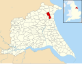 Burton Agnes UK parish locator map.svg 1,425 × 1,107; 1.68 MB
-
 Burton Agnes village pond - geograph.org.uk - 4176719.jpg 1,535 × 1,600; 217 KB
-
 Burton Agnes village pond - geograph.org.uk - 5552050.jpg 1,024 × 768; 607 KB
-
 Burton Agnes village war memorial - geograph.org.uk - 5552051.jpg 1,024 × 768; 877 KB
-
 Burton Agnes, hall courtyard and church - geograph.org.uk - 4494776.jpg 640 × 426; 206 KB
-
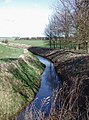 Burton Drain - geograph.org.uk - 708059.jpg 473 × 640; 121 KB
-
 Burtoncarr House Farm - geograph.org.uk - 6453418.jpg 800 × 541; 118 KB
-

-

-

-

-
 Byway across Thornholme Field - geograph.org.uk - 6653745.jpg 1,024 × 768; 229 KB
-
 Byway south of Woldgate - geograph.org.uk - 6653757.jpg 1,024 × 768; 221 KB
-
 Carpet of snowdrops - geograph.org.uk - 2812366.jpg 1,024 × 725; 407 KB
-
 Carr Lane Plantation - geograph.org.uk - 1256545.jpg 640 × 480; 138 KB
-
 Carr Lane Plantation - geograph.org.uk - 5403187.jpg 640 × 330; 33 KB
-
 Chalky farmland south of Woldgate - geograph.org.uk - 3732093.jpg 640 × 480; 64 KB
-
 Chalky farmland south of Woldgate - geograph.org.uk - 3732104.jpg 640 × 480; 91 KB
-
 Chalky field - geograph.org.uk - 4161704.jpg 640 × 480; 88 KB
-
 Church at Burton Agnes - geograph.org.uk - 688621.jpg 640 × 480; 58 KB
-

-

-

-
 Communications Mast on Woldgate - geograph.org.uk - 6687547.jpg 1,065 × 1,600; 710 KB
-
 Conservation or Shooting take your pick - geograph.org.uk - 4795950.jpg 3,456 × 4,608; 5.38 MB
-
 Corn on the cob field near Burton Agnes - geograph.org.uk - 6686858.jpg 1,600 × 1,065; 688 KB
-
 Cottage on Main Street (A614) - geograph.org.uk - 4160247.jpg 640 × 480; 52 KB
-
 Cottage on Shady Lane, Burton Agnes - geograph.org.uk - 1933165.jpg 640 × 480; 65 KB
-
 Cottage, Burton Agnes - geograph.org.uk - 4160236.jpg 640 × 448; 55 KB
-
 Country lane north to Woldgate - geograph.org.uk - 5219576.jpg 2,298 × 1,720; 1.44 MB
-
 Crocus, Burton Agnes - geograph.org.uk - 2809403.jpg 752 × 1,024; 266 KB
-
 Crop field and hedgerow - geograph.org.uk - 3732086.jpg 640 × 480; 69 KB
-
 Crop field east of Back Lane - geograph.org.uk - 4160723.jpg 640 × 467; 85 KB
-
 Crop field east of Back Lane - geograph.org.uk - 4160921.jpg 640 × 441; 86 KB
-
 Crop field off Back Lane - geograph.org.uk - 4160715.jpg 640 × 480; 86 KB
-
 Crop field off Woldgate - geograph.org.uk - 3732063.jpg 640 × 480; 68 KB
-
 Crop field off Woldgate Roman Road - geograph.org.uk - 4371892.jpg 640 × 480; 118 KB
-
 Crop field south of Woldgate - geograph.org.uk - 3732065.jpg 640 × 480; 90 KB
-
 Crop field south of Woldgate - geograph.org.uk - 3732071.jpg 640 × 480; 97 KB
-
 Crop field south of Woldgate - geograph.org.uk - 3732074.jpg 640 × 480; 75 KB
-
 Crop field south of Woldgate - geograph.org.uk - 3732088.jpg 640 × 480; 61 KB
-
 Crop field south of Woldgate - geograph.org.uk - 3732186.jpg 640 × 480; 81 KB
-
 Crop field south of Woldgate - geograph.org.uk - 3732211.jpg 640 × 480; 41 KB
-
 Crop field, Burton Agnes Field - geograph.org.uk - 4361233.jpg 640 × 480; 101 KB
-
 Crop field, Wandales - geograph.org.uk - 4356746.jpg 640 × 480; 73 KB
-
 Crow Wood - geograph.org.uk - 1408674.jpg 640 × 480; 79 KB
-
 Crow Wood - geograph.org.uk - 5136501.jpg 640 × 480; 81 KB
-
 Cyclists on National cycle route 1 - geograph.org.uk - 4371886.jpg 640 × 412; 59 KB
-
 Dem bones - geograph.org.uk - 2821074.jpg 812 × 1,024; 351 KB
-
 Demming Drain - geograph.org.uk - 6453406.jpg 800 × 600; 130 KB
-
 Demmings Drain - geograph.org.uk - 5416896.jpg 640 × 426; 36 KB
-
 Direction sign on National Cycle Route 1 - geograph.org.uk - 5136454.jpg 640 × 519; 153 KB
-
 Drain and fields - geograph.org.uk - 6453414.jpg 800 × 600; 138 KB
-
 Duck pond at Burton Agnes - geograph.org.uk - 4497683.jpg 1,024 × 768; 222 KB
-
 Dumped tyres - geograph.org.uk - 5979349.jpg 1,024 × 768; 267 KB
-
 Dwarfed by giant trees - geograph.org.uk - 2809430.jpg 827 × 1,024; 387 KB
-
 Early arrivals - geograph.org.uk - 2812329.jpg 1,024 × 768; 220 KB
-
 East Field, Burton Agnes - geograph.org.uk - 464185.jpg 640 × 478; 108 KB
-
 Ee-why service station, Thornholme - geograph.org.uk - 5136519.jpg 640 × 398; 45 KB
-

-

-
 Elizabeth II postbox on Station Road, Burton Agnes - geograph.org.uk - 5133337.jpg 2,109 × 2,740; 1.33 MB
-

-
 End of Stone Pit Plantation - geograph.org.uk - 5219007.jpg 2,296 × 1,716; 2.24 MB
-
 End of the village speed limit - geograph.org.uk - 2094821.jpg 1,024 × 768; 99 KB
-
 Entering Burton Agnes - geograph.org.uk - 4160151.jpg 640 × 387; 44 KB
-
 Entering Burton Agnes, A614 - geograph.org.uk - 5429764.jpg 640 × 426; 66 KB
-
 Entering Gransmoor, East Yorkshire - geograph.org.uk - 2206643.jpg 800 × 600; 235 KB
-
 Entering Thornholme, A614 - geograph.org.uk - 5429763.jpg 640 × 426; 66 KB
-
 Entrance to Woodside Farm - geograph.org.uk - 6653884.jpg 1,024 × 768; 179 KB
-
 Estate cottages on Station Road Burton Agnes - geograph.org.uk - 6615480.jpg 4,608 × 3,456; 3.28 MB
-
 Farm buildings off Back Lane - geograph.org.uk - 4160696.jpg 640 × 480; 72 KB
-
 Farm buildings, Thornholme - geograph.org.uk - 4356369.jpg 640 × 480; 69 KB
-

-
 Farm road to Thornholme Moor Farm - geograph.org.uk - 4795910.jpg 4,608 × 3,456; 3.68 MB
-

-

-
 Farm track near Wharram Hill - geograph.org.uk - 5805908.jpg 1,600 × 1,065; 606 KB
-
 Farm Track north of Park House - geograph.org.uk - 1324838.jpg 640 × 480; 58 KB
-
 Farm track off Back Lane - geograph.org.uk - 4160927.jpg 640 × 423; 72 KB
-
-
 Farmhouse, Burton Agnes - geograph.org.uk - 4160188.jpg 640 × 480; 69 KB
-
 Farmland and hedgerow - geograph.org.uk - 3732059.jpg 640 × 480; 62 KB
-

-

-

-
 Farmland and hedgerow, Wandales - geograph.org.uk - 4356741.jpg 640 × 480; 73 KB
-

-
 Farmland and woodland - geograph.org.uk - 4160946.jpg 640 × 480; 72 KB
-
 Farmland beside Rudston Road - geograph.org.uk - 4161677.jpg 640 × 480; 96 KB
-
 Farmland between Rudston and Burton Agnes - geograph.org.uk - 6538604.jpg 1,179 × 884; 461 KB
-
 Farmland East Field - geograph.org.uk - 4161604.jpg 640 × 480; 57 KB
-
 Farmland east of Back Lane - geograph.org.uk - 4160711.jpg 640 × 384; 49 KB
-
 Farmland near Butoncarr House - geograph.org.uk - 1256570.jpg 640 × 480; 98 KB
-

-
 Farmland near Thornholme - geograph.org.uk - 4160066.jpg 640 × 480; 83 KB
-
 Farmland near Woodside Farm - geograph.org.uk - 1256646.jpg 640 × 480; 51 KB
-
 Farmland north of Horse Carr Lane - geograph.org.uk - 5805914.jpg 1,600 × 1,065; 609 KB
-

-
 Farmland off Rudston Road - geograph.org.uk - 4161699.jpg 640 × 480; 90 KB
-
 Farmland off Woldgate - geograph.org.uk - 4456480.jpg 640 × 428; 58 KB
-
 Farmland SE Of Burton Agnes - geograph.org.uk - 366548.jpg 640 × 480; 100 KB
-
 Farmland south of Woldgate - geograph.org.uk - 3732080.jpg 640 × 480; 77 KB
-
 Farmland south of Woldgate - geograph.org.uk - 3732220.jpg 961 × 628; 122 KB
-
 Farmland south of Woldgate - geograph.org.uk - 3732222.jpg 640 × 480; 47 KB
-
 Farmland south of Woldgate - geograph.org.uk - 3732227.jpg 640 × 480; 63 KB
-
 Farmland south of Woldgate - geograph.org.uk - 3732234.jpg 640 × 480; 67 KB
-
 Farmland south of Woldgate - geograph.org.uk - 3732236.jpg 640 × 480; 72 KB


_-_geograph.org.uk_-_2164765.jpg)


_-_geograph.org.uk_-_4160239.jpg)


,_Burton_Agnes_-_geograph.org.uk_-_4356371.jpg)

,_Burton_Agnes_-_geograph.org.uk_-_4356711.jpg)


_-_geograph.org.uk_-_4160247.jpg)


