Category:Burg Bechthal
Jump to navigation
Jump to search
| Object location | | View all coordinates using: OpenStreetMap |
|---|
This is the category of the Bavarian Baudenkmal (cultural heritage monument) with the ID D-5-77-163-19 (Wikidata)
|
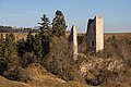
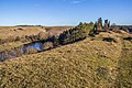
Deutsch: Die Burg Bechthal ist eine Burgruine im Landkreis Weißenburg-Gunzenhausen. Burg des 12./13. Jahrhundert; Bergfried, weiterer schmaler Turmrest sowie Mauerreste auf der Südseite erhalten
Deutsch: Hochmittelalterliche Burgruine Bechthal bei Raitenbuch (Landkreis Weißenburg-Gunzenhausen, Mittelfranken)
English: High Middle Ages castle ruin Bechthal near Raitenbuch (Landkreis Weißenburg-Gunzenhausen, Middle Franconia, Germany)
castle  | |||||
| Upload media | |||||
| Instance of | |||||
|---|---|---|---|---|---|
| Location | Raitenbuch, Weißenburg-Gunzenhausen, Middle Franconia, Bavaria, Germany | ||||
| Street address |
| ||||
| Has part(s) |
| ||||
| Heritage designation | |||||
 | |||||
Media in category "Burg Bechthal"
The following 17 files are in this category, out of 17 total.
-
 Burg Bechthal 01.jpg 4,960 × 3,308; 4.02 MB
-
 Burg Bechthal 02.jpg 4,297 × 3,265; 2.53 MB
-
 Burg Bechthal 03.jpg 3,456 × 5,184; 4.79 MB
-
 Burg Bechthal 04.jpg 3,410 × 5,115; 4.34 MB
-
 Burg Bechthal 05.jpg 3,456 × 5,184; 4.47 MB
-
 Burg Bechthal 06.jpg 4,893 × 3,263; 3.37 MB
-
 Burg Bechthal 07.jpg 4,777 × 3,184; 3.17 MB
-
 Burg Bechthal 08.jpg 8,307 × 3,117; 5.92 MB
-
 Burg Bechthal 09.jpg 4,957 × 3,306; 5.48 MB
-
 Burg Bechthal 2.jpg 800 × 397; 294 KB
-
 Burg Bechthal 3.jpg 600 × 800; 494 KB
-
 Burg Bechthal 4.jpg 600 × 800; 554 KB
-
 Burg Bechthal 5.jpg 800 × 600; 422 KB
-
 Burg Bechthal.jpg 800 × 405; 335 KB
-
 Burgruine Bechtal.jpg 1,000 × 670; 247 KB
-
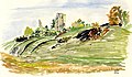 Ruine Bechthal Aquarell von Siegfried Schieweck-Mauk, Eichstätt.jpg 1,117 × 653; 147 KB
-
 Ruine Bechthal.JPG 2,560 × 1,920; 3.39 MB


