Category:Burg Altlaubenberg
Jump to navigation
Jump to search
| Object location | | View all coordinates using: OpenStreetMap |
|---|
castle  | |||||
| Upload media | |||||
| Instance of | |||||
|---|---|---|---|---|---|
| Location | Grünenbach, Lindau, Swabia, Bavaria, Germany | ||||
| Street address |
| ||||
| Heritage designation | |||||
| Inception |
| ||||
 | |||||
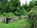
This is the category of the Bavarian Baudenkmal (cultural heritage monument) with the ID D-7-76-113-25 (Wikidata)
|
Deutsch: Burgruine Altlaubenberg, Mauerreste der seit 1719 weitgehend abgetragenen Burg; Gedenkstein von 1935.
Subcategories
This category has only the following subcategory.
G
Media in category "Burg Altlaubenberg"
The following 5 files are in this category, out of 5 total.
-
 Alt-Laubenberg (2).jpg 325 × 262; 112 KB
-
 Alt-Laubenberg.jpg 357 × 232; 125 KB
-
 Burgruine Altlaubenberg GO-1.jpg 2,592 × 1,944; 2.01 MB
-
 Burgruine Altlaubenberg GO-3.jpg 2,592 × 1,944; 1.92 MB
-
 Grünenbach - Ruine Altlaubenberg v S, Grünenbach.JPG 2,272 × 1,704; 968 KB
.jpg)


