Category:Bundorfer Forst
Jump to navigation
Jump to search
unincorporated area in Germany   | |||||
| Upload media | |||||
| Instance of |
| ||||
|---|---|---|---|---|---|
| Named after |
| ||||
| Location | Rhön-Grabfeld, Lower Franconia, Bavaria, Germany | ||||
| Population |
| ||||
| Area |
| ||||
 | |||||
Subcategories
This category has the following 2 subcategories, out of 2 total.
N
S
- Sumpfgraben (Baunach) (2 F)
Media in category "Bundorfer Forst"
The following 13 files are in this category, out of 13 total.
-
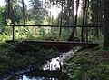
 Baunach-Bundorfer Forst-MR001.jpg 4,075 × 3,005; 3.59 MB
-
 Baunach-Bundorfer Forst-MR002.jpg 4,769 × 2,660; 3.54 MB
-
 Baunach-Bundorfer Forst-MR003.jpg 4,547 × 3,326; 4.39 MB
-
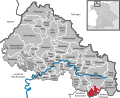 Bundorfer Forst in NES.svg 672 × 550; 1.97 MB
-
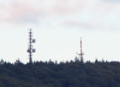 Funktuerme Nassacher Hoehe28092022.png 1,905 × 1,378; 2.55 MB
-
 Grenzstein im Bundorfer Forst westlich von Kimmelsbach.jpg 4,000 × 4,432; 10.35 MB
-
 Grenzstein westlich des Nesselgrunds im Bundorfer Forst.jpg 2,976 × 4,304; 8.92 MB
-
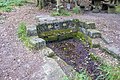 Molkenbrunnen am Baunachsee.jpg 6,000 × 4,000; 10.71 MB
-
 Waldweg südlich von Sulzfeld.jpg 4,000 × 3,000; 4.84 MB
-
 Waldweg östlich von Eichelsdorf.jpg 3,973 × 2,970; 3.52 MB
-
 Wiese am Weg im Westen des Naturschutzgebiets Nesselgrund.jpg 6,000 × 4,000; 14.49 MB
-
 Wiese östlich von Eichelsdorf 2.jpg 4,000 × 3,000; 2.87 MB
-
 Wiese östlich von Eichelsdorf.jpg 4,000 × 3,000; 2.11 MB


